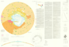
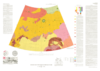
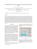
The Ice Favorability Index (IFI) maps below are based on a geologic system model for ice deposition and evolution (Cannon and Britt 2020). The index maps are predictive, not based on surface ice…
Planetary nomenclature, like terrestrial nomenclature, is used to uniquely identify a feature on the surface of a planet or satellite so that the feature can be easily located, described, and…
In January 2004 the first European interplanetary spacecraft, Mars Express, was inserted successfully into a Martian orbit. The multiline scanner HRSC (High Resolution Stereo Camera) on board of…
This paper presents the technology and experimental results for high-precision landing-site mapping and rover localization developed for the ongoing 2003 Mars Exploration Rover (MER) mission. This…
Our project aims to automate Mars mapping and localization using robotic stereo and descent imagery. Stereo vision is a wellstudied domain. However, most efforts aim only at a general scene; little…
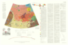
In a previous research effort a terrain partition framework was defined allowing the partition of the landscape of Valles Marineris chasma (an elongated steep-sided depression located in Mars) to…
Following the conceptual idea "from 3D camera to 3D view", the production of true-3D image maps for the glasses-free stereoviewing of parts of the Martian surface, is described. The image data have…
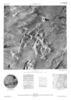
In general, maps should answer a very simple question of its reader: "what's there" and „where is something”? For planetary maps, the answer is more difficult, because (1) in some cases even map…
Crater Size-Frequency Distributions (SFD) on planetary surfaces are crucial to dating the geological age. On the Moon they have been employed together with radioactive K-Ar techniques to determine…
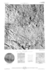
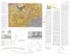
The High Resolution Stereo Camera (HRSC) on board of the European space mission Mars Express provides multispectral digital image data in high resolution as well as the systematic stereo coverage of…
MULTI-DIMENSIONAL CHARACTERIZATION OF IMPACT EJECTA DEPOSITS FROM METEOR CRATER, AZ. T. A. Gaither, J. J. Hagerty, S. E. Clark, T. M. Hare, R. K. Hayward, H. E. Newsom, S. P. Wright, and J. McHone,…
A NEW REPOSITORY FOR DRILL HOLE SAMPLES AND REMOTE SENSING DATA FROM METEOR CRATER, AZ J. J. Hagerty, S. E. Clark, T. M. Hare, R. K. Hayward, H. E. Newsom, S. P. Wright, and J. McHone, U.S.G.S.…