Products

1000 Results Collapse
Mars Year 24-28 MOC WA Red and Blue 2023 thumbnail

Mars Year 24-28 MOC WA Red and Blue 2023

application/pds-lab 168 kB

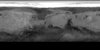
NASA's Mars Global Surveyor spacecraft contained the Mars Orbiter Camera, which had a wide-angle (MOC-WA) system sensitive to narrow, 50 nm-wide ranges of purple ('blue') and orange ('red') light. …

Mars Viking Lander 2 Rectified Photomosaics thumbnail

Mars Viking Lander 2 Rectified Photomosaics

application/pdf 9 MBNov 23 2023

Mars Viking Lander 1 Rectified Photomosaics thumbnail

Mars Viking Lander 1 Rectified Photomosaics

application/pdf 9 MBNov 21 2023

Mars Controlled Mosaic of the Canberra Region thumbnail

Mars Controlled Mosaic of the Canberra Region

application/pdf 6 MBOct 16 2023

Mars Controlled Mosaic of the Yorktown Region thumbnail

Mars Controlled Mosaic of the Yorktown Region

application/pdf 8 MBOct 16 2023

Project Pages

30 Results Collapse

Documents

132 Results Collapse
ISPRS 2003 Mars Digital Image Model (MDIM) 2.1 Control Network thumbnail

ISPRS 2003 Mars Digital Image Model (MDIM) 2.1 Control Network

application/pdf 277 kB

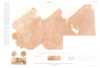
USGS is currently preparing a new version of its global Mars digital image mosaic, which will be known as MDIM 2.1. As part of this process we are completing a new photogrammetric solution of the…

ISPRS 2004 Multi-Image Shape from Shading, Derivation of Planetary Digital Terrain Models Using Clementine Images thumbnail

ISPRS 2004 Multi-Image Shape from Shading, Derivation of Planetary Digital Terrain Models Using Clementine Images

application/pdf 627 kB

In many cases, the derivation of high-resolution digital terrain models (DTMs) from planetary surfaces using only conventional digital image matching is a problem. The matching methods need at least…

ISPRS 2004 De- and Re-Shading of Mars Express HRSC Image Data for Homogenization of Map Relief Shading thumbnail

ISPRS 2004 De- and Re-Shading of Mars Express HRSC Image Data for Homogenization of Map Relief Shading

application/pdf 735 kB

Within the Photogrammetry and Cartography Group (PCG) of the Mars Express HRSC (High Resolution Stereo Scanner Camera) Co-Investigator Science Team, the main task of which is the development and…

ISPRS 2004 Combining Mars Data in GRASS GIS for Geologic Mapping thumbnail

ISPRS 2004 Combining Mars Data in GRASS GIS for Geologic Mapping

application/pdf 662 kB

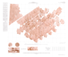
Geo Information Systems (GIS) are standard tools in the Earth sciences whenever different geographic data sets must be combined. GIS became increasingly popular in the field of planetary research as…

ISPRS 2004 Cartography of the Saturnian Satellites thumbnail

ISPRS 2004 Cartography of the Saturnian Satellites

application/pdf 1 MB

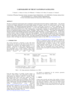
We have re-measured control points and re-computed a control point network for Saturn’s satellite Dione. Our network is based on 16 images (obtained by the narrow-angle cameras of Voyager I and…

ISPRS 2004 The Mapping Performance of the HRSC / SRC in Mars Orbit thumbnail

ISPRS 2004 The Mapping Performance of the HRSC / SRC in Mars Orbit

application/pdf 2 MB

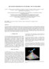
The images obtained by the HRSC (High Resolution Stereo Camera) on Mars Express show excellent potential for topographic mapping of the planet. The derived stereo models agree with topographic data…

ISPRS 2004 Mars Digital Image Model (MDIM 2.1) Control Network thumbnail

ISPRS 2004 Mars Digital Image Model (MDIM 2.1) Control Network

application/pdf 382 kB

Positional control for MDIM 2.1 comes from a new geodetic/photogrammetric solution of the global Mars Mariner 9 and Viking image control network. The details of this network solution are described…

ISPRS 2004 Topographic Mapping of Mars from Hectometer to Micrometer Scales thumbnail

ISPRS 2004 Topographic Mapping of Mars from Hectometer to Micrometer Scales

application/pdf 2 MB

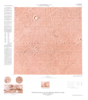
We describe USGS topomapping of Mars at resolutions from 100 m to 30 µm with data from the latest spacecraft missions. Analysis of NASA 2001 Mars Odyssey Thermal Emission Imaging System (THEMIS)…

ISPRS 2004 Combined Bundle Adjustment of MOC Stereo Images and MOLA Altimetry Data for Precise Mars Topographic Mapping thumbnail

ISPRS 2004 Combined Bundle Adjustment of MOC Stereo Images and MOLA Altimetry Data for Precise Mars Topographic Mapping

application/pdf 184 kB

Launched in 1996, Mars Global Surveyor (MGS) carries two types of mapping equipments: Mars Orbiter Laser Altimeter (MOLA) and Mar Orbiter Camera (MOC). MOLA collects accurate laser altimetry data…

ISPRS 2004 Improving the Exterior Orientation of Mars Express HRSC Imagery thumbnail

ISPRS 2004 Improving the Exterior Orientation of Mars Express HRSC Imagery

application/pdf 132 kB

This paper focusses on the estimation of exterior orientation parameters of the High Resolution Stereo Camera (HRSC) orbiting planet Mars during the European Mars Express mission since January 2004.…