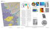
Mars Geologic Map of MTM 35337, 40337, and 45337 Quadrangles, Deuteronilus Mensae Region
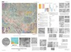
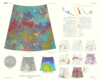
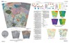
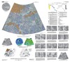
application/pdf 9 MBJan 09 2009Deuteronilus Mensae, first defined as an albedo feature at lat 35.0 deg N., long 5.0 deg E., by U.S. Geological Survey (USGS) and International Astronomical Union (IAU) nomenclature, is a gradational…