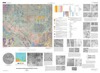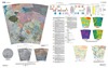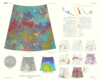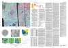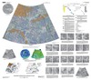

Venus Geologic Map of the Meskhent Tessera Quadrangle (V-3)
The Magellan spacecraft orbited Venus from August 10, 1990, until it plunged into the Venusian atmosphere on October 12, 1994. Magellan Mission objectives included (1) improving the knowledge of the geological processes, surface properties, and geologic history of Venus by analysis of surface radar characteristics, topography, and morphology and (2) improving the knowledge of the geophysics of Venus by analysis of Venusian gravity. The Meskhent Tessera quadrangle is in the northern hemisphere of Venus and extends from lat 50 degrees to 75 degrees N. and from long 60 degrees to 120 degrees E. In regional context, the Meskhent Tessera quadrangle is surrounded by extensive tessera regions to the west (Fortuna and Laima Tesserae) and to the south (Tellus Tessera) and by a large basinlike lowland (Atalanta Planitia) on the east. The northern third of the quadrangle covers the easternmost portion of the large topographic province of Ishtar Terra (northwestern map area) and the more localized upland of Tethus Regio (northeastern map area).
- Mimetype
- application/pdf
- Filename
- Venus-Geologic-Map-of-the-Meskhent-Tessera-Quadrangle-V-3.pdf
- Publisher
- USGS Astrogeology Science Center
- Publication Date
- 8 January 2008
- Author
- Mikhail A. Ivanov and James W. Head, III
- Originator
- Group
- Added to Astropedia
- 21 April 2016
- Modified
- 3 November 2017
General
- Geospatial Data Presentation Form
- Geologic Map, Raster Data, Vector Data
- Series Id
- 3018
Keywords
- Target
- Venus
- Theme
- Cartography, Geology, Geomorphology, Photogeology, Stratigraphy, Planetary evolution
- Mission
Contact and Distribution
- Access Instructions
- Report: ii, 16 p.; Map Sheet: 47 x 42 inches
Geospatial Information
- Minimum Latitude
- 50
- Maximum Latitude
- 75
- Minimum Longitude
- 60
- Maximum Longitude
- 120
- Quad Name
- V-3