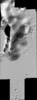
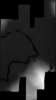
This is a shaded-relief of the digital elevation model (DEM) extracted from the Lunar Reconnaissance Orbiter Camera (LROC) Narrow Angle Camera (NAC) stereo images from the Lunar Reconnaissance…
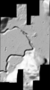
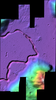
This raster dataset represents a confidence value or figure of merit (FOM) for each pixel for the digital elevation model (DEM) as extracted from the Lunar Reconnaissance Orbiter Camera (LROC) Narrow…
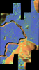
This is a slope-colorized shaded-relief of the digital elevation model (DEM) extracted from the Lunar Reconnaissance Orbiter Camera (LROC) Narrow Angle Camera (NAC) stereo images from the Lunar…
This is a colorized shaded-relief of the digital elevation model (DEM) extracted from the Lunar Reconnaissance Orbiter Camera (LROC) Narrow Angle Camera (NAC) stereo images from the Lunar…
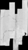
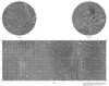
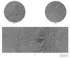
This is a visible image mosaic generated using Lunar Reconnaissance Orbiter Camera (LROC) Narrow Angle Camera (NAC) images from the Lunar Reconnaissance Orbiter mission. The images were…
This is a digital elevation model (DEM) extracted from the Lunar Reconnaissance Orbiter Camera (LROC) Narrow Angle Camera (NAC) stereo images from the Lunar Reconnaissance Orbiter mission. The…
Planetary nomenclature, like terrestrial nomenclature, is used to uniquely identify a feature on the surface of a planet or satellite so that the feature can be easily located, described, and…