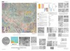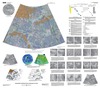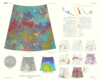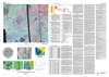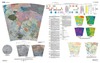

Venus Geologic Map of the Helen Planitia Quadrangle (V-52)
The Magellan spacecraft orbited Venus from August 10, 1990, until it plunged into the Venusian atmosphere on October 12, 1994. Magellan Mission objectives included (1) improving the knowledge of the geological processes, surface properties, and geologic history of Venus by analysis of surface radar characteristics, topography, and morphology and (2) improving the knowledge of the geophysics of Venus by analysis of Venusian gravity. The Helen Planitia quadrangle (V-52), located in the southern hemisphere of Venus between lat 25 deg S. and 50 deg S. and between long 240 deg E. and 270 deg E., covers approximately 8,000,000 km2. Regionally, the map area is located at the southern limit of an area of enhanced tectonomagmatic activity and extensional deformation, marked by a triangle that has highland apexes at Beta, Atla, and Themis Regiones (BAT anomaly) and is connected by the large extensional belts of Devana, Hecate, and Parga Chasmata. The BAT anomaly covers approximately 20 percent of the Venusian surface.
- Mimetype
- application/pdf
- Filename
- Venus-Geologic-Map-of-the-Helen-Planitia-Quadrangle-V-52.pdf
- Publisher
- USGS Astrogeology Science Center
- Publication Date
- 8 January 2008
- Author
- Ivan Lopez and Vicki L. Hansen
- Originator
- Group
- Added to Astropedia
- 21 April 2016
- Modified
- 3 November 2017
General
- Geospatial Data Presentation Form
- Geologic Map, Raster Data, Vector Data
- Series Id
- 3026
Keywords
- Target
- Venus
- Theme
- Cartography, Geology, Geomorphology, Photogeology, Stratigraphy, Planetary evolution
- Mission
Contact and Distribution
- Access Instructions
- Report: ii, 22 p.; Plate: 56 x 35.5 inches
Geospatial Information
- Minimum Latitude
- -50
- Maximum Latitude
- -25
- Minimum Longitude
- 240
- Maximum Longitude
- 270
- Quad Name
- V-52