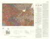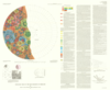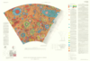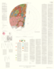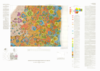

Mercury Geologic Map of the Kuiper Quadrangle
- Mimetype
- application/pdf
- Filename
- Mercury-Geologic-Map-of-the-Kuiper-Quadrangle.pdf
- Publisher
- USGS Astrogeology Science Center
- Publication Date
- 20 November 1981
- Originator
- R. De Hon, D. Scott, J. Underwood
- Group
- RPIF
- Added to Astropedia
- 1 April 2016
- Modified
- 13 March 2018
General
- Geospatial Data Presentation Form
- Geologic Map, Raster Data, Vector Data
- Series Id
- 1233
Keywords
- Target
- Mercury
- Theme
- Cartography, Geology, Geomorphology, Photogeology, Stratigraphy, Planetary evolution
- Mission
Contact and Distribution
- Access Instructions
- 1 map :col. ;44 x 61 cm.
Geospatial Information
- Minimum Latitude
- -22
- Maximum Latitude
- 22
- Minimum Longitude
- 288
- Maximum Longitude
- 360
- Quad Name
- H-6