
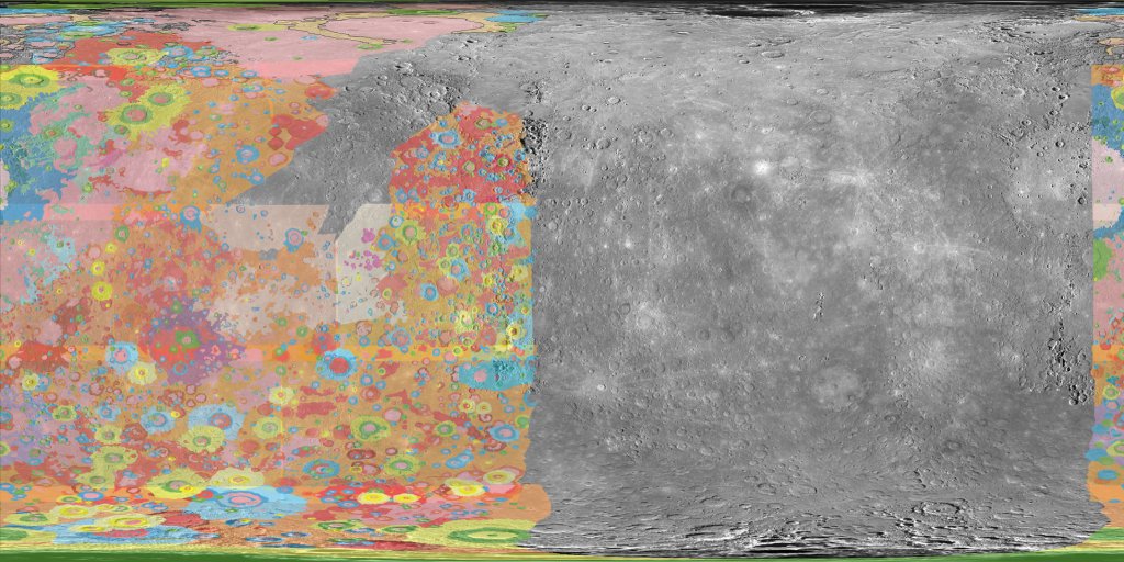
Mercury 5M GIS Conversion v2
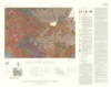
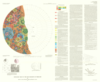
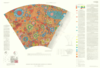
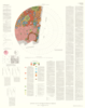
These polygons are beased on the original created 1:5M geologic maps for Mercury as published in the late 80's and early 90's as created by several authors. The original GIS conversion was completed in 1999 using older photomosaic bases as part of a larger digitization effort. To make this dataset more useful with modern data it has been smoothed (ArcGIS PAEK smoothing method with a tolerance of 10 km) and transformed (projective transformation) to align with the 2013 Messenger base map. Links used to transform the data are included with this documentation. A polyline feature class was then derived from the polygons and attributed with contact types. All datasets use the slightly smaller Mercury radius of 2439000 m rather than the Mercury 2000 radius of 2439700 m.
References:
Geologic Map of the Bach Region of Mercury; H-15; Strom, RG, et al.
Geologic Map of the Beethoven Quadrangle of Mercury; H-7; King, J.S., et al.
Geologic Map of the Borealis Region of Mercury; H-01; Grolier, M.J., et al.
Geologic Map of the Discovery Quadrangle of Mercury; H-11; Trask, N.J., et al.
Geologic Map of the Kuiper Quadrangle of Mercury; H-6; De Hon, Rene, et al.
Geologic Map of the Michelangelo Quadrangle of Mercury; H-12; Spudis, P.D., et al.
Geologic Map of the Shakespeare Quadrangle of Mercury; H-3; Guest, John, et al.
Geologic Map of the Tolstoj Quadrangle of Mercury; H-8; Schaber, G.G., et al.
Geologic Map of the Victoria Quadrangle of Mercury; H-2; McGill, George, et al.
All mid 80' to early 90's
http://planetarymapping.wr.usgs.gov/Target/project/16
- Mimetype
- application/zip
- Filename
- Mercury_5M_GIS_conversion_v2.zip
- Publisher
- USGS Astrogeology Science Center
- Publication Date
- 16 May 2016
- Author
- Marc Hunter
- Originator
- Donna Galuszka
- Group
- MRCTR
- Added to Astropedia
- 12 August 2016
- Modified
- 30 May 2019
General
- Purpose
Updated converted GIS maps to a more current MESSENGER base map.
- Geospatial Data Presentation Form
- Geologic Map
- Edition
- 2.0
- Native Data Set Environment
- ESRI Arcinfo, GDAL
- Color
- Color
- Supplemental Information
- http://planetarymapping.wr.usgs.gov/Target/project/16
Keywords
- Target
- Mercury
- Theme
- Geology, Geographic Information System (GIS), Photogeology
- Mission
- Mariner
- Mission Specific
- Mariner 10
- Search Terms
- Mercury, Geology, GIS
Contact and Distribution
- Access Constraints
- None
- Use Constraints
- None
Data Status and Quality
- Time Period of Content Begin
- 1 April 2016
- Time Period of Content End
- 16 May 2016
- Currentness Reference
- Publication date
- Progress
- Complete
- Update Frequency
- None planned
- Logical Consistency Report
- warped original GIS layers to more current MESSENGER-based base map
- Completeness Report
These do not cover Mercury. Coverage only available for original maps.
- Process Description
To make the original GIS conversion more useful with modern data it has been smoothed (ArcGIS PAEK smoothing method with a tolerance of 10 km) and transformed (projective transformation) to align with the 2013 Messenger basemap. Links used to transform the data are included with this documentation.
- Horizontal Positional Accuracy Report
- Best Effort
- Vertical Positional Accuracy Report
- Best Effort
Lineage
- Source PDS Archive
- Magellan
- Source Originator
- USGS Astrogeology
- Source Publication Date
- 1 April 1999
- Source Title
- Geologic Maps of the yyyy Region of Mars
- Source Online Linkage
- http://planetarymapping.wr.usgs.gov/Target/project/16
- Type of Source Media
- Online
- Attribute Accuracy Report
- Best Effort
Geospatial Information
- Minimum Latitude
- -90
- Maximum Latitude
- 90
- Minimum Longitude
- -180
- Maximum Longitude
- 180
- Direct Spatial Reference Method
- Vector
- Object Type
- Polygon
- Quad System
- Mercury 1:5M
- Quad Name
- Radius A
- 2439000
- Radius C
- 2439000
- Control Net
- MESSENGER
- Horizontal Coordinate System Units
- Meters
- Map Projection Name
- Simple Cylindrical
- Latitude Type
- Planetocentric
- Longitude Direction
- Positive East
- Longitude Domain
- -180 to 180