Products

110 Results Collapse
ISPRS 1999 SSI / RAC: Imagers for Mars Polar Lander thumbnail

ISPRS 1999 SSI / RAC: Imagers for Mars Polar Lander

application/pdf 27 kB

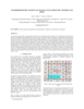
The Mars Volatiles and Climate Surveyor (MVACS) instrument payload on the Mars Polar Lander includes two imagers designed and constructed at the Lunar and Planetary Laboratory at the University of…

ISPRS 1999 Location and Geologic Settings for the three U. S. Mars Landers thumbnail

ISPRS 1999 Location and Geologic Settings for the three U. S. Mars Landers

application/pdf 15 kB

Super resolution of the horizon at both Viking landing sites has revealed “new” features we use for triangulation, similar to the approach used during the Mars Pathfinder Mission. We propose…

ISPRS 2004 Automation in Mars Landing-Site Mapping and Rover Localization thumbnail

ISPRS 2004 Automation in Mars Landing-Site Mapping and Rover Localization

application/pdf 603 kB

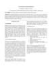
Our project aims to automate Mars mapping and localization using robotic stereo and descent imagery. Stereo vision is a wellstudied domain. However, most efforts aim only at a general scene; little…

ISPRS 2003 Utilizing GIS in Martian Impact Crater Studies thumbnail

ISPRS 2003 Utilizing GIS in Martian Impact Crater Studies

application/pdf 545 kB

The Mars Crater Morphology Consortium was formed in 1997 to facilitate exchange of martian impact crater data among researchers through standardizing nomenclature, integrating crater databases into…

ISPRS 2004 Geomorphometric Mapping of Grand Canyon from the 1-Degree USGS DEMs thumbnail

ISPRS 2004 Geomorphometric Mapping of Grand Canyon from the 1-Degree USGS DEMs

application/pdf 946 kB

In a previous research effort a terrain partition framework was defined allowing the partition of the landscape of Valles Marineris chasma (an elongated steep-sided depression located in Mars) to…

ISPRS 2003 GIS 101 for Planetary Research thumbnail

ISPRS 2003 GIS 101 for Planetary Research

application/pdf 156 kB

GIS-like tools have existed in the computer age since scientists have been displaying images or comparing digital datasets. Whether it was a program on a mainframe to draw a satellite image to…

ISPRS 2004 Quantitative Assessment of Automated Crater Detection on Mars thumbnail

ISPRS 2004 Quantitative Assessment of Automated Crater Detection on Mars

application/pdf 456 kB

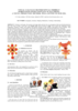
Crater Size-Frequency Distributions (SFD) on planetary surfaces are crucial to dating the geological age. On the Moon they have been employed together with radioactive K-Ar techniques to determine…

ISPRS 2004 Combined Bundle Adjustment of MOC Stereo Images and MOLA Altimetry Data for Precise Mars Topographic Mapping thumbnail

ISPRS 2004 Combined Bundle Adjustment of MOC Stereo Images and MOLA Altimetry Data for Precise Mars Topographic Mapping

application/pdf 184 kB

Launched in 1996, Mars Global Surveyor (MGS) carries two types of mapping equipments: Mars Orbiter Laser Altimeter (MOLA) and Mar Orbiter Camera (MOC). MOLA collects accurate laser altimetry data…

ISPRS 2003 Visual Calculus of Perceptual Fribble? World Maps with Constant Scale Edges: A Novel Projection Method, Well-Suited to our Era thumbnail

ISPRS 2003 Visual Calculus of Perceptual Fribble? World Maps with Constant Scale Edges: A Novel Projection Method, Well-Suited to our Era

application/pdf 3 MB

I introduce world maps with constant scale edges [cse], and show how cse encompasses both conventional projections and a new class of maps—world maps with constant scale natural boundaries [csnb].…

Project Pages

6 Results Collapse

Documents

24 Results Collapse