Sub-ice Volcanism on Earth and Mars
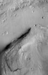
http://astrogeology.usgs.gov/geology/mars-volcano-ice-interactionsSub-glacially erupted volcanoes form free-standing flat-topped mesas, known as tuyas. Although there are some silicic edifices (e.g. Tuffen et al., 2002), most terrestrial sub-ice volcanoes are mafic…