Products

110 Results Collapse
Mars Geologic Map of Cydonia Mensae-Southern Acidalia Planitia thumbnail

Mars Geologic Map of Cydonia Mensae-Southern Acidalia Planitia

application/pdf 25 MBJan 05 2005

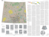
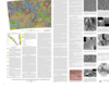
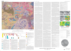
Cydonia Mensae lie adjacent to the boundary separating the highland terrain of western Arabia Terra from the northern lowlands (the dichotomy boundary), where this boundary is gradational rather than…

Mars Geologic Map of the Northern Plains thumbnail

Mars Geologic Map of the Northern Plains

application/pdf 61 MBJan 05 2005

The northern plains of Mars cover nearly a third of the planet and constitute the planet's broadest region of lowlands. Apparently formed early in Mars' history, the northern lowlands served as a…

Mars Geologic Map of MTM -45252 and -45257 Quadrangles, Reull Vallis Region thumbnail

Mars Geologic Map of MTM -45252 and -45257 Quadrangles, Reull Vallis Region

application/pdf 8 MBJan 03 2003

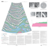
Mars Transverse Mercator (MTM) quadrangles -45252 and -45257 (latitude 42.5° S. to 47.5°S., longitude 250° W. to 260° W.) cover a portion of the highlands of Promethei Terra east of…

Mars Geologic Map of the MTM 85080 Quadrangle, Chasma Boreale Region thumbnail

Mars Geologic Map of the MTM 85080 Quadrangle, Chasma Boreale Region

application/pdf 10 MBJan 03 2003

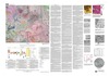
The polar deposits on Mars probably record martian climate history over the last 107 to 109 years (for example, Thomas and others, 1992). The area shown on this map includes polar layered deposits…

Venus Geologic Map of the Rusalka Planitia Quadrangle (V-25) thumbnail

Venus Geologic Map of the Rusalka Planitia Quadrangle (V-25)

application/pdf 46 MBJan 03 2003

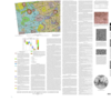
The Rusalka Planitia quadrangle (herein referred to as V-25) occupies an 8.1 million square kilometer swath of lowlands nestled within the eastern highlands of Aphrodite Terra on Venus. The region…

Mars Topographic and Color-Coded Contour Maps thumbnail

Mars Topographic and Color-Coded Contour Maps

application/pdf 2 MBJan 03 2003

Moon Color-Coded Topography and Shaded Relief Maps of the Lunar Hemispheres thumbnail

Moon Color-Coded Topography and Shaded Relief Maps of the Lunar Hemispheres

application/pdf 44 MBJan 02 2002

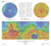
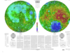
This publication is a set of three sheets of topographic maps that presents color-coded topographic data digitally merged with shaded relief data. Adopted figure: The figure for the Moon, used for…

Mars Geologic Map of MTM -40252 and -40257 Quadrangles, Reull Vallis Region thumbnail

Mars Geologic Map of MTM -40252 and -40257 Quadrangles, Reull Vallis Region

application/pdf 16 MBJan 02 2002

Mars Transverse Mercator (MTM) quadrangles -40252 and -40257 cover a portion of the highlands of Promethei Terra northeast of the Hellas basin. The map area consists of heavily cratered ancient…

Mars Geologic Map Transecting the Highland/Lowland Boundary Zone, Arabia Terra thumbnail

Mars Geologic Map Transecting the Highland/Lowland Boundary Zone, Arabia Terra

application/pdf 36 MBJan 02 2002

Arabia Terra is a large region of cratered terrane extending from about 20° W. longitude eastward across the prime meridian to about 300° W. longitude for an average east-west width of about…

Venus Geologic Map of the Diana Chasma Quadrangle (V-37) thumbnail

Venus Geologic Map of the Diana Chasma Quadrangle (V-37)

application/pdf 19 MBJan 02 2002

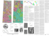
Introduction The Diana Chasma quadrangle (V-37), an equatorial region between 0° to 25° S. and 150° to 180° E. that encompasses ~8,400,000 km2, is broadly divided into southern Rusalka…

Project Pages

6 Results Collapse

Documents

24 Results Collapse
Shocked Anorthosite and Pyroxenite thumbnail
Full Paper Submitted 8-07-04 thumbnail

Full Paper Submitted 8-07-04

application/pdf 2 MB