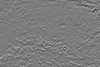
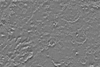
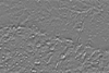
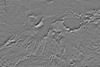
This product is an infrared image mosaic generated using Thermal Emission Imaging System (THEMIS) images from the 2001 Mars Odyssey orbiter mission. The mosaic is generated at the full resolution of…
The Mars Transverse Mercator (MTM) Map Series has been used to publish geologic and controlled photomosaic maps of Mars since 1984. Traditionally maps were published using planetographic coordinates…
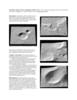
This paper presents techniques for automatic mapping of Mars landing sites using surface-based images, i.e., those taken by Mars landers and/or rovers. An innovative method for automatic tie point…
We describe a series of programs and scripts under development for the USGS digital cartography and image processing software system ISIS that will make it possible for users to create digital…
Viking Orbiter, MOC and MOLA data are being used to construct three dimensional landmark templates on Mars which can be aligned with a variety of data types for navigation on future missions and…
The Mars Crater Morphology Consortium was formed in 1997 to facilitate exchange of martian impact crater data among researchers through standardizing nomenclature, integrating crater databases into…
USGS is currently preparing a new version of its global Mars digital image mosaic, which will be known as MDIM 2.1. As part of this process we are completing a new photogrammetric solution of the…
Geo Information Systems (GIS) are standard tools in the Earth sciences whenever different geographic data sets must be combined. GIS became increasingly popular in the field of planetary research as…
We have re-measured control points and re-computed a control point network for Saturn’s satellite Dione. Our network is based on 16 images (obtained by the narrow-angle cameras of Voyager I and…
Positional control for MDIM 2.1 comes from a new geodetic/photogrammetric solution of the global Mars Mariner 9 and Viking image control network. The details of this network solution are described…
We describe USGS topomapping of Mars at resolutions from 100 m to 30 µm with data from the latest spacecraft missions. Analysis of NASA 2001 Mars Odyssey Thermal Emission Imaging System (THEMIS)…