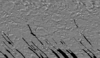
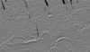
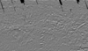
This product is an infrared image mosaic generated using Thermal Emission Imaging System (THEMIS) images from the 2001 Mars Odyssey orbiter mission. The mosaic is generated at the full resolution of…
Planetary nomenclature, like terrestrial nomenclature, is used to uniquely identify a feature on the surface of a planet or satellite so that the feature can be easily located, described, and…
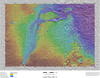
The Magellan spacecraft went into Venus orbit in 1990 and by 1992 had made three complete cycles of polar orbits, each cycle covering the full range of longitudes. During this time the spacecraft…
The current global spatial control net of Mars provides the geodetic basis for an orthoimage map composed of image data sets obtained from VIKING missions from 1976 to 1980. This map is not…
The stereo photogrammetric observable equations are presented relating control point image location to camera distortions, camera pointing, spacecraft position, Mars-fixed areocentric control point…
NASA's Mars Geodesy/Cartography Working Group (MGCWG), established in 1998 and chaired since 2000 by one of us (TCD), consists of leading researchers in planetary geodesy and cartography at such…
Though the primary focus at Malin Space Science Systems (MSSS) is on building and operating instruments through the archiving of raw data, we have also pursued research interests in planetary…
A basic requirement for the planning of future Mars missions are precise and high resolution maps, especially, of the landing site area. We present a new digital orthoimage map of Mars using data…
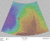
The current Mars Global Survey (MGS) mission has been collecting high resolution digital images (MOC) and laser ranges (MOLA). The processing MOLA range data results in a global digital elevation…
We describe our initial experiences producing controlled digital elevation models (DEMs) of Mars with horizontal resolutions of ≤10 m and vertical precisions of ≤2 m. Such models are of intense…
In this paper we focus on a detail concerning the estimation of exterior orientation parameters of the High Resolution Stereo Camera (HRSC) orbiting planet Mars during the European Mars Express…