Products

567 Results Collapse
Mars Controlled Mosaic of the Yorktown Region thumbnail

Mars Controlled Mosaic of the Yorktown Region

application/pdf 8 MBOct 16 2023

Report of the IAU Working Group on Cartographic Coordinates and Rotational Elements: 2015 thumbnail

Report of the IAU Working Group on Cartographic Coordinates and Rotational Elements: 2015

application/pdf 711 kBOct 27 2017

This report continues the practice where the IAU Working Group on Cartographic Coordinates and Rotational Elements revises recommendations regarding those topics for the planets, satellites, minor…

THEMIS Night IR Controlled Mosaic Eridania 65S 120E 100 mpp thumbnail

THEMIS Night IR Controlled Mosaic Eridania 65S 120E 100 mpp

application/isis 704 MBJul 20 2017

This product is an infrared image mosaic generated using Thermal Emission Imaging System (THEMIS) images from the 2001 Mars Odyssey orbiter mission. The mosaic is generated at the full resolution of…

THEMIS Day IR Controlled Mosaic Eridania 65S 120E 100 mpp thumbnail

THEMIS Day IR Controlled Mosaic Eridania 65S 120E 100 mpp

application/isis 704 MBJul 20 2017

This product is an infrared image mosaic generated using Thermal Emission Imaging System (THEMIS) images from the 2001 Mars Odyssey orbiter mission. The mosaic is generated at the full resolution of…

THEMIS Night IR Controlled Mosaic Thaumasia 65S 240E 100 mpp thumbnail

THEMIS Night IR Controlled Mosaic Thaumasia 65S 240E 100 mpp

application/isis 704 MBJul 20 2017

This product is an infrared image mosaic generated using Thermal Emission Imaging System (THEMIS) images from the 2001 Mars Odyssey orbiter mission. The mosaic is generated at the full resolution of…

THEMIS Day IR Controlled Mosaic Thaumasia 65S 240E 100 mpp thumbnail

THEMIS Day IR Controlled Mosaic Thaumasia 65S 240E 100 mpp

application/isis 704 MBJul 20 2017

This product is an infrared image mosaic generated using Thermal Emission Imaging System (THEMIS) images from the 2001 Mars Odyssey orbiter mission. The mosaic is generated at the full resolution of…

Project Pages

10 Results Collapse

Documents

60 Results Collapse
ISPRS 1999 Location and Geologic Settings for the three U. S. Mars Landers thumbnail

ISPRS 1999 Location and Geologic Settings for the three U. S. Mars Landers

application/pdf 15 kB

Super resolution of the horizon at both Viking landing sites has revealed “new” features we use for triangulation, similar to the approach used during the Mars Pathfinder Mission. We propose…

ISPRS 1999 A New Viking-Based Precise Global Map of Mars thumbnail

ISPRS 1999 A New Viking-Based Precise Global Map of Mars

application/pdf 10 kB

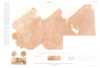
We present a new global map of Mars based on images taken by the Viking Orbiters. Precise image position information and camera pointing data, needed to produce this map, were derived from a recent…

ISPRS 1999 Geometrically Precise Maps and their Applications thumbnail

ISPRS 1999 Geometrically Precise Maps and their Applications

application/pdf 39 kB

We re-analyzed the Viking Mars control point network, an effort, which resulted in accurate pointing data for a list of 1138 Viking Orbiter images. From these images, which have resolutions between…

ISPRS 1999 Global Mapping and Individual Map Sheets - The Topographic Image Map Series Mars 1:200 000 thumbnail

ISPRS 1999 Global Mapping and Individual Map Sheets - The Topographic Image Map Series Mars 1:200 000

application/pdf 193 kB

More than ever before the planet Mars is subject to exploration and mapping activities. Since 1992 the Technical University of Berlin was involved in the software development for photogrammetric and…

ISPRS 1999 Constraints, Approach, and Status of Mars Surveyor '01 Landing Site Selection thumbnail

ISPRS 1999 Constraints, Approach, and Status of Mars Surveyor '01 Landing Site Selection

application/pdf 13 kB

There are many similarities between the Mars Surveyor '01 (MS '01) landing site selection process and that of Mars Pathfinder. The selection process includes two parallel activities in which…

ISPRS 1999 Status of the Rand-USGS Control Network of Mars thumbnail

ISPRS 1999 Status of the Rand-USGS Control Network of Mars

application/pdf 6 kB

The RAND-USGS control network of Mars is a combination of the RAND control network and the USGS network.

ISPRS 2001 Utilizing Mars Digital Image Model (MDIM) and Mars Orbiter laser Altimeter (MOLA) data for photogrammetric control thumbnail

ISPRS 2001 Utilizing Mars Digital Image Model (MDIM) and Mars Orbiter laser Altimeter (MOLA) data for photogrammetric control

application/pdf 32 kB

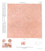
The USGS is producing digital elevation models (DEM) and topographic maps of Mars at scales of 1:250,000 to 1:1,000,000. The initial source material will be Viking Orbiter images, with a later…

ISPRS 2001 Combining Lunar Photogrammetric Topographic Data with Clementine LIDAR Data thumbnail

ISPRS 2001 Combining Lunar Photogrammetric Topographic Data with Clementine LIDAR Data

application/pdf 35 kB

During the Clementine Mission both oblique and vertical multispectral images were collected. The oblique and vertical images from a single spectral band collected during the same orbit form a stereo…

ISPRS 2001 An Orthoimage Map using data obtained from the Mars Orbiter Camera of Mars Global Surveyor thumbnail

ISPRS 2001 An Orthoimage Map using data obtained from the Mars Orbiter Camera of Mars Global Surveyor

application/pdf 42 kB

A basic requirement for the planning of future, perhaps even manned Mars missions are precise and high resolution maps of our neighbour planet and, especially, of the landing area. Here we present a…

ISPRS 2001 High Resolution Digital Elevation Models of Mars from MOC Narrow Angle Stereoimages thumbnail

ISPRS 2001 High Resolution Digital Elevation Models of Mars from MOC Narrow Angle Stereoimages

application/pdf 296 kB

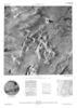
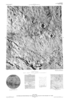
In this abstract we report on our initial experiences performing stereotopographic mapping of Mars with high-resolution images from the Mars Global Surveyor Mars Orbiter Camera Narrow-Angle subsystem…