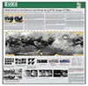
In 2003-2005, the USGS worked under the guidance of NASA's Mars Critical Data Products Initiative to conduct research on how controlled large area or global 2001 Mars Odyssey THEMIS IR image mosaics…
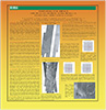
The Cassini mission has returned an abundance of data about the surface of Titan. To maximize the science return from these data and to assist with planning for Cassini and future missions, we have…
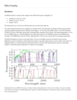
Cassini RADAR SARtopo and altimetry data are used to construct a global gridded 1 x 1° elevation map, for use in Global Circulation Models, hydrological models and correlative studies. The data are…