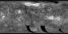
This product has been superseded by Magellan Global Topography 4641m v02 (1997). Global Topographic Data Record (GTDR). The range to surface is derived by fitting altimeter echoes from the fan-beam…
A global monochrome mosaic of the best resolution images from both Galileo and Voyager 1 was created that includes 51 Voyager 1 images with spatial resolutions sometimes exceeding the 1 km/pixel…
The images used for the base of this globe were chosen from the best image quality and moderate resolution coverage supplied by Galileo SSI and Voyager 1 and 2 (Batson, 1987; Becker and others, 1998;…
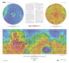
The color shaded relief image used as the base for this globe has a resolution of 32 pixels per degree (approximately 1850 m/pixel), and was produced and supplied by the MOLA Science Team. The image…
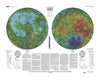
The photomosaic that forms the base for this globe was created by merging two global digital image models (DIM's) of Mars, a medium-resolution monochrome mosaic processed to emphasize topographic…
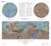
The photomosaic that forms the base for this globe combines a gray-shaded relief airbrush image with color-coded topographic data. The shaded relief data provide interpretations of lunar morphology…
This sheet is one in a series of topographic maps that presents colorcoded topographic data digitally merged with shaded relief data. The figure for the Moon, used for the computation of the map…
This map is based on data from the Mars Orbiter Laser Altimeter (MOLA) (Smith and others, 2001), an instrument on NASA's Mars Global Surveyor (MGS) spacecraft (Albee and others, 2001). The image used…
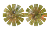
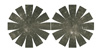
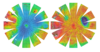
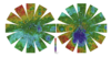
Project sheet with instructions for creating the Viking and Global Surveyor Mars globes using tennis balls.