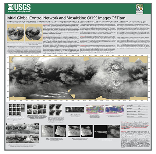
Initial Global Control Network and Mosaicking Of ISS Images of Titan LPSC 2013 Poster
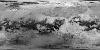
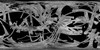
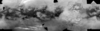
The Cassini mission has returned an abundance of data about the surface of Titan. To maximize the science return from these data and to assist with planning for Cassini and future missions, we have begun the process of rigorously registering images and ancillary data from Cassini's ISS and RADAR instruments into a single, consistent, precise global Titan reference frame and have created the first controlled near global (all longitudes, +45° to -65° latitude) ISS mosaic of Titan (Figures 1 to 3). This has been done via a controlled, photogram- metric least squares bundle adjustment.
- Mimetype
- application/pdf
- Filename
- Archinal-LPSC13-Titan-poster_v2-smaller.pdf
- Originator
- USGS Astrogeology Science Center
- Group
- Added to Astropedia
- 18 June 2013
- Modified
- 9 July 2013
General
- Geospatial Data Presentation Form
- Poster
Keywords
- System
- Saturn
- Target
- Titan
- Mission
- Cassini-Huygens
- Instrument
- ISS
Geospatial Information
- Quad Name