Products

244 Results Collapse
PDS MC Face-To-Face Meeting, 19-20 April 2017, Pasadena, CA thumbnail

PDS MC Face-To-Face Meeting, 19-20 April 2017, Pasadena, CA

application/vnd.openxmlformats-officedocument.spreadsheetml.sheet 44 kB

Information for Instrument Teams thumbnail
Venus Magellan Global Meter Scale Slope 4641m v1 thumbnail

Venus Magellan Global Meter Scale Slope 4641m v1

application/isis 33 MB

Product Information: In this Global Slope Data Record (GSDR) the surface meter-scale slopes are derived by fitting altimeter echoes from the fan-beam altimetry antenna as a function of time to…

Hawaii_Analog_Pit_Crater_Data.zip thumbnail

Hawaii_Analog_Pit_Crater_Data.zip

application/zip 995 MBSep 28 2016

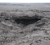
Abstract Diurnal and annual temperature variations in some Atypical Pit Craters (APCs) on Mars may be affected by the presence of interior cave entrances (Cushing et al., 2007; Cushing et al.,…

ISPRS 1999 SSI / RAC: Imagers for Mars Polar Lander thumbnail

ISPRS 1999 SSI / RAC: Imagers for Mars Polar Lander

application/pdf 27 kB

The Mars Volatiles and Climate Surveyor (MVACS) instrument payload on the Mars Polar Lander includes two imagers designed and constructed at the Lunar and Planetary Laboratory at the University of…

ISPRS 1999 The UCL IUS-Tithonium Chasma Digital Elevation Model thumbnail

ISPRS 1999 The UCL IUS-Tithonium Chasma Digital Elevation Model

application/pdf 93 kB

We re-examine a previously unpublished digital elevation model (DEM) of a ~105,000km2 area (figure 1) of Tithonium and Ius Chasma area, produced by the EXODUS (Extraterrestrial Orbital DEMs for…

ISPRS 2004 Mars Digital Image Model (MDIM 2.1) Control Network thumbnail

ISPRS 2004 Mars Digital Image Model (MDIM 2.1) Control Network

application/pdf 382 kB

Positional control for MDIM 2.1 comes from a new geodetic/photogrammetric solution of the global Mars Mariner 9 and Viking image control network. The details of this network solution are described…

ISPRS 2004 Improving the Exterior Orientation of Mars Express HRSC Imagery thumbnail

ISPRS 2004 Improving the Exterior Orientation of Mars Express HRSC Imagery

application/pdf 132 kB

This paper focusses on the estimation of exterior orientation parameters of the High Resolution Stereo Camera (HRSC) orbiting planet Mars during the European Mars Express mission since January 2004.…

ISPRS 2004 Digital Cartography with HRSC on Mars Express thumbnail

ISPRS 2004 Digital Cartography with HRSC on Mars Express

application/pdf 8 MB

The High Resolution Stereo Camera (HRSC) on board of the European space mission Mars Express provides multispectral digital image data in high resolution as well as the systematic stereo coverage of…

ISPRS 2004 Quantitative Assessment of Automated Crater Detection on Mars thumbnail

ISPRS 2004 Quantitative Assessment of Automated Crater Detection on Mars

application/pdf 456 kB

Crater Size-Frequency Distributions (SFD) on planetary surfaces are crucial to dating the geological age. On the Moon they have been employed together with radioactive K-Ar techniques to determine…

Project Pages

2 Results Collapse

Documents

180 Results Collapse
ISPRS 1999 Status of the Rand-USGS Control Network of Mars thumbnail

ISPRS 1999 Status of the Rand-USGS Control Network of Mars

application/pdf 6 kB

The RAND-USGS control network of Mars is a combination of the RAND control network and the USGS network.

ISPRS 1999 Examining Mars with Spice thumbnail

ISPRS 1999 Examining Mars with Spice

application/pdf 4 kB

The International Mars Conference highlights the wealth of scientific data now and soon to be acquired from an international armada of Mars-bound robotic spacecraft. Underlying the planning and…

ISPRS 1999 MOLA: The Future of Mars Global Cartography thumbnail

ISPRS 1999 MOLA: The Future of Mars Global Cartography

application/pdf 29 kB

The MGS Orbiter is carrying the high-precision Mars Orbiter Laser Altimeter (MOLA) which, when combined with precision reconstructed orbital data and telemetered attitude data, provides a tie between…

ISPRS 1999 Visualizing Mars using Virtual Reality: A State of the Art Mapping Technique used on Mars Pathfinder thumbnail

ISPRS 1999 Visualizing Mars using Virtual Reality: A State of the Art Mapping Technique used on Mars Pathfinder

application/pdf 13 kB

We describe an interactive terrain visualization system which rapidly generates and interactively displays photorealistic three-dimensional (3-D) models produced from stereo images. This product,…

ISPRS 2001 Comparison of Shape Models for 433 Eros using Imaging and Altimetry thumbnail

ISPRS 2001 Comparison of Shape Models for 433 Eros using Imaging and Altimetry

application/pdf 52 kB

The NEAR mission produced shape models of asteroid 433 Eros by both the imaging team and the altimetry team. Preliminary models by both teams at the 2 degree x 2 degree resolution, equivalent to…

ISPRS 2001 The Accuracy, Stability and

ISPRS 2001 The Accuracy, Stability and "Value" of Geodetic Reference Parameters for Mars

application/pdf 51 kB

Recent geodetic observations of Mars by the Mars Global Surveyor spacecraft, particularly the altimetry and gravity experiments, have provided a new framework in which Mars may be geodetically…

ISPRS 2001 Topographic Mapping of the Galilean and Other Icy Satellites: Prospects and Problems for Stereo and Photoclinometry thumbnail

ISPRS 2001 Topographic Mapping of the Galilean and Other Icy Satellites: Prospects and Problems for Stereo and Photoclinometry

application/pdf 107 kB

The utility (read: need) of topographic data in formulating and testing hypotheses for the formation of geologic features is undisputed. In the absence of laser altimeters, however, image-based…

ISPRS 2001 Utilizing Mars Digital Image Model (MDIM) and Mars Orbiter laser Altimeter (MOLA) data for photogrammetric control thumbnail

ISPRS 2001 Utilizing Mars Digital Image Model (MDIM) and Mars Orbiter laser Altimeter (MOLA) data for photogrammetric control

application/pdf 32 kB

The USGS is producing digital elevation models (DEM) and topographic maps of Mars at scales of 1:250,000 to 1:1,000,000. The initial source material will be Viking Orbiter images, with a later…

ISPRS 2001 Combining Lunar Photogrammetric Topographic Data with Clementine LIDAR Data thumbnail

ISPRS 2001 Combining Lunar Photogrammetric Topographic Data with Clementine LIDAR Data

application/pdf 35 kB

During the Clementine Mission both oblique and vertical multispectral images were collected. The oblique and vertical images from a single spectral band collected during the same orbit form a stereo…

ISPRS 2001 An Orthoimage Map using data obtained from the Mars Orbiter Camera of Mars Global Surveyor thumbnail

ISPRS 2001 An Orthoimage Map using data obtained from the Mars Orbiter Camera of Mars Global Surveyor

application/pdf 42 kB

A basic requirement for the planning of future, perhaps even manned Mars missions are precise and high resolution maps of our neighbour planet and, especially, of the landing area. Here we present a…