In general, maps should answer a very simple question of its reader: "what's there" and „where is something”? For planetary maps, the answer is more difficult, because (1) in some cases even map…
Following the conceptual idea "from 3D camera to 3D view", the production of true-3D image maps for the glasses-free stereoviewing of parts of the Martian surface, is described. The image data have…
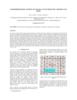
In a previous research effort a terrain partition framework was defined allowing the partition of the landscape of Valles Marineris chasma (an elongated steep-sided depression located in Mars) to…
Our project aims to automate Mars mapping and localization using robotic stereo and descent imagery. Stereo vision is a wellstudied domain. However, most efforts aim only at a general scene; little…
This paper presents the technology and experimental results for high-precision landing-site mapping and rover localization developed for the ongoing 2003 Mars Exploration Rover (MER) mission. This…
In January 2004 the first European interplanetary spacecraft, Mars Express, was inserted successfully into a Martian orbit. The multiline scanner HRSC (High Resolution Stereo Camera) on board of…
Launched in 1996, Mars Global Surveyor (MGS) carries two types of mapping equipments: Mars Orbiter Laser Altimeter (MOLA) and Mar Orbiter Camera (MOC). MOLA collects accurate laser altimetry data…
We describe USGS topomapping of Mars at resolutions from 100 m to 30 µm with data from the latest spacecraft missions. Analysis of NASA 2001 Mars Odyssey Thermal Emission Imaging System (THEMIS)…
The images obtained by the HRSC (High Resolution Stereo Camera) on Mars Express show excellent potential for topographic mapping of the planet. The derived stereo models agree with topographic data…
We have re-measured control points and re-computed a control point network for Saturn’s satellite Dione. Our network is based on 16 images (obtained by the narrow-angle cameras of Voyager I and…
High precision topographic information from all available data is critical to many landing site geological and engineering applications. Meanwhile, precise navigation and localization of the rover is…
In this abstract we report on our initial experiences performing stereotopographic mapping of Mars with high-resolution images from the Mars Global Surveyor Mars Orbiter Camera Narrow-Angle subsystem…
The Magellan spacecraft went into Venus orbit in 1990 and by 1992 had made three complete cycles of polar orbits, each cycle covering the full range of longitudes. During this time the spacecraft…
The current global spatial control net of Mars provides the geodetic basis for an orthoimage map composed of image data sets obtained from VIKING missions from 1976 to 1980. This map is not…
Digitization and cartographic processing of 5 Lunar Orbiter (LO) IV frames (109H, 110H, 114H, 115H, and 114M) are now complete, and these data are available online at…
The stereo photogrammetric observable equations are presented relating control point image location to camera distortions, camera pointing, spacecraft position, Mars-fixed areocentric control point…
NASA's Mars Geodesy/Cartography Working Group (MGCWG), established in 1998 and chaired since 2000 by one of us (TCD), consists of leading researchers in planetary geodesy and cartography at such…
Though the primary focus at Malin Space Science Systems (MSSS) is on building and operating instruments through the archiving of raw data, we have also pursued research interests in planetary…
As a result of imagery returned from the Galileo spacecraft, the Galilean satellites have been the focus of a great deal of scientific research and general public interest. New control networks and…
We present here our current results from photogrammetric triangulation solutions for a control network and reference surface for Jupiter’s moon Io. It is compared to previous such solutions by us…