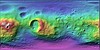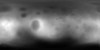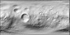
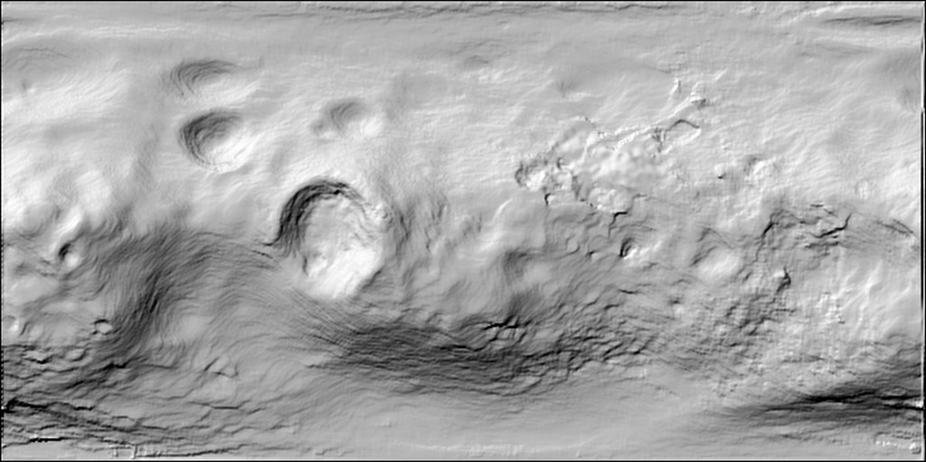
Phobos Mars Express HRSC Shaded Relief Global 100m v1
Product Information:
This is a shaded-relief of the original Digital Elevation Model (DEM) produced from images from the High Resolution Stereo Camera (HRSC) aboard the European Space Agency's (ESA) Mars Express. Resolution is 100 meters per pixel (m). HRSC images were used to obtain three-dimensional coordinates of surface points of Phobos and used to derive the DEM. At the time the HRSC could not yet gain global coverage so the data was complimented by Viking orbiter image data to be able to provide the digital terrain model globally (Willner et al., 2010).
Mission and Instrument Information:
Mars Express is a mission of the European Space Agency (ESA) it launched in June 2003 onboard a Soyuz-Fregat launcher from the Baikonur Cosmodrome in Kazakhstan. There are seven instrument suites onboard Mars Express: Aspera Energetic Neutral Atoms Analyzer (ASPERA), High/Super Resolution Stereo Colour Imager (HRSC, SRC), Mars Radio Science Experiment, Mars Subsurface Sounding Radar/Altimeter (MARSIS), Omega IR Mineralogical Mapping Spectrometer (Omega), Planetary Fourier Spectrometer (PFS), and UV and IR Atmospheric Spectrometer (SPICAM).
The instrumentation onboard Mars Express was designed to reach the scientific objectives of the mission which include: global high-resolution photogeology at 10 m per pixel resolution, super resolution photogeology of selected areas of the planet at 2 meters per pixel, global high spatial resolution mineralogical mapping at a resolution range from a kilometer per pixel to several 100 meters per pixel, global atmospheric circulation characterization, subsurface characterization, surface-atmosphere interaction, structure of the interior and surface geochemistry and exobiology.
Phobos is a very irregular body often approximated by a tri-axial ellipsoid for simplicity. With a mean distance of only 9375 km to the center of Mars – which relates to approximately 6000 km above the Martian surface – it is orbiting deep in the Martian gravity field. Its orbit is in a nearly equatorial plane and almost circular.
The research leading to the data products has received funding from the European Community's Seventh Framework Programme ([FP7/2007-2013]) under grant agreement number 263466 for the FP7-ESPaCE program. https://doi.org/10.1016/j.epsl.2009.07.033
Reference:
Willner, K., Oberst, J., Hussmann, H., Giese, B., Hoffman, H., Matz, K.-D., Roatsch, T., & Duxbury, T. (2010). Phobos control point network, rotation, and shape. Earth and Planetary Science Letters, 294(3–4), 541-546. https://doi.org/10.1016/j.epsl.2009.07.033
- Publisher
- Europlanet Research Infrastructure
- Publication Date
- 1 June 2009
- Author
- Mars Express HRSC Instrument Team
- Originator
- Group
- PDS
- Added to Astropedia
- 1 December 2015
- Modified
- 3 February 2020
General
- Purpose
The German Aerospace Center (DLR) was involved in an in-depth study of Phobos, a natural satellite of Mars. Based on images of the multi-spectral line scanning High Resolution Stereo Camera (HRSC) and the Super Resolution Channel (SRC) – a frame camera – the department of Planetary Geodesy was to observe Phobos in its orbit, determined shape parameters computed global digital elevation models, prepared a first low scale maps based on image data only, derived new estimates on its rotational parameters and could derive mass distribution models agreeing to all other constraining parameters.
- Geospatial Data Presentation Form
- Digital Elevation Model, Remote-sensing Data, Shaded-Relief Map
- Edition
- 0.1
- Online Linkage
- https://planetarymaps.usgs.gov/mosaic/Phobos_ME_HRSC_Shade_Global_2ppd.tif
- Native Data Set Environment
- ISIS v3
- Supplemental Information
- http://www.sciencedirect.com/science/article/pii/S0012821X09004506, https://www.dlr.de/dlr/en/desktopdefault.aspx/tabid-10364/548_read-400/#/gallery/657, https://pds-imaging.jpl.nasa.gov/volumes/viking.html#vkoEDR
Keywords
- System
- Mars
- Target
- Phobos
- Theme
- Remote Sensing, Topography
- Mission
- Mars Express
- Instrument
- HRSC
- Search Terms
- Topography, Remote Sensing, Satellites
Contact and Distribution
- Access Constraints
- public domain
- Use Constraints
- Please cite authors
Data Status and Quality
- Time Period of Content Begin
- 1 January 2003
- Time Period of Content End
- 31 December 2009
- Currentness Reference
- Ground condition
- Progress
- In Work
- Update Frequency
- As needed
- Logical Consistency Report
- HRSC images were used to obtain 3-dimensional coordinates of surface points of Phobos (Willner et al., 2010).
- Completeness Report
As currently the HRSC could not gain global coverage yet, the data was complimented by Viking orbiter image data to be able to provide the digital terrain model globally. It is anticipated to further improve and update the terrain model, the preliminary image mosaics, and maps with more image data available.
- Process Date
- 9 November 2015
- Process Description
Hillshade processing was completed using Geospatial Data Abstraction Library (GDAL) tools on the original DEM. > > gdaldem hillshade input_dem output_hillshade -z 2 (ZFactor) -az 315 (Azimuth) -alt 45 (Altitude)
- Horizontal Positional Accuracy Report
- Best Effort
- Entity and Attribute Overview
- Shaded-relief, or hillshading, simulates shadows cast upon a raised topographic map, or more abstractly upon the planetary surface.
- Entity and Attribute Linkage
- http://www.gdal.org/gdaldem.html
Lineage
- PDS Status
- PDS 3 Like
- Source PDS Archive
- Mars Express
- Source Originator
- Europlanet Research Infrastructure
- Source Publication Date
- 1 June 2009
- Source Title
- Phobos
- Source Online Linkage
- https://pds-imaging.jpl.nasa.gov/volumes/mex.html , https://pds-imaging.jpl.nasa.gov/portal/mex_mission.html
- Type of Source Media
- Online
- Attribute Accuracy Report
- Best Effort
Geospatial Information
- Minimum Latitude
- -90.15
- Maximum Latitude
- 90
- Minimum Longitude
- -180.15
- Maximum Longitude
- 180.66
- Direct Spatial Reference Method
- Raster
- Object Type
- Pixel
- Lines (pixels)
- 349
- Samples (pixels)
- 699
- Bit Type
- 8
- Quad Name
- Radius A
- 11100
- Radius C
- 11100
- Bands
- 1
- Pixel Resolution (meters/pixel)
- 100
- Scale (pixels/degree)
- 2
- Horizontal Coordinate System Units
- Meters
- Map Projection Name
- Simple Cylindrical
- Latitude Type
- Planetocentric
- Longitude Direction
- Positive East
- Longitude Domain
- -180 to 180