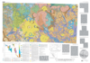
Mars Geologic Map of the Northern Plains
The northern plains of Mars cover nearly a third of the planet and constitute the planet's broadest region of lowlands. Apparently formed early in Mars' history, the northern lowlands served as a repository both for sediments shed from the adjacent ancient highlands and for volcanic flows and deposits from sources within and near the lowlands. Geomorphic evidence for extensive tectonic deformation and reworking of surface materials through release of volatiles occurs throughout the northern plains. In the polar region, Planum Boreum contains evidence for the accumulation of ice and dust, and surrounding dune fields suggest widespread aeolian transport and erosion. The most recent regional- and global-scale maps describing the geology of the northern plains are largely based on Viking Orbiter image data (Dial, 1984; Witbeck and Underwood, 1984; Scott and Tanaka, 1986; Greeley and Guest, 1987; Tanaka and Scott, 1987; Tanaka and others, 1992a; Rotto and Tanaka, 1995; Crumpler and others, 2001; McGill, 2002). These maps reveal highland, plains, volcanic, and polar units based on morphologic character, albedo, and relative ages using local stratigraphic relations and crater counts. This geologic map of the northern plains is the first published map that covers a significant part of Mars using topography and image data from both the Mars Global Surveyor and Mars Odyssey missions. The new data provide a fresh perspective on the geology of the region that reveals many previously unrecognizable units, features, and temporal relations. In addition, we adapted and instituted terrestrial mapping methods and stratigraphic conventions that we think result in a clearer and more objective map. We focus on mapping with the intent of reconstructing the history of geologic activity within the northern plains, including deposition, volcanism, erosion, tectonism, impact cratering, and other processes with the aid of comprehensive crater-density determinations. Mapped areas include all plains regions within the northern hemisphere of Mars, as well as an approximately 300-km-wide strip of cratered highland and volcanic regions, which border the plains. Note that not all of the contiguous northern plains are mapped, because some minor parts of Elysium and Amazonis Planitiae lie south of the equator.
- Mimetype
- application/pdf
- Filename
- Mars-Geologic-Map-of-the-Northern-Plains.pdf
- Publisher
- USGS Astrogeology Science Center
- Publication Date
- 5 January 2005
- Originator
- K. Tanaka, J. Skinner, T. Hare
- Group
- RPIF
- Added to Astropedia
- 3 May 2016
- Modified
- 21 September 2018
General
- Geospatial Data Presentation Form
- Geologic Map, Raster Data, Vector Data
- Series Id
- 2888
Keywords
- Target
- Mars
- Theme
- Cartography, Geology, Geomorphology, Photogeology, Stratigraphy, Planetary evolution
- Mission
Contact and Distribution
- Access Instructions
- Map: 57.90 x 42.44 inches; Pamphlet: i, 27 p.
Geospatial Information
- Minimum Latitude
- 0
- Maximum Latitude
- 90
- Minimum Longitude
- 0
- Maximum Longitude
- 360
- Quad Name
- Map Projection Name
- Polar Stereographic