
Mars Geologic Map of the MTM -20272 and -25272 Quadrangles, Tyrrhena Terra Region
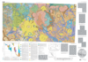
Introduction Mars Transverse Mercator (MTM) -20272 and -25272 quadrangles (lat 17.5?-27.5? S., long 270?-275? W.) cover part of the highlands of Tyrrhena Terra north of Hellas Planitia. The surface of the Tyrrhena Terra region records a complex history of impact cratering and modification by fluvial and eolian activity. The map area consists primarily of intercrater plains, impact crater material, and crater floor material. An extensive valley network, Vichada Valles, as well as several smaller networks, dissects the northern part of the map area. The abundance and widespread nature of fluvial features within the map area have significant implications for past Martian environmental conditions. The degraded terrains surrounding Hellas Planitia provide constraints on the role and timing of volatile-driven activity in the evolution of the highlands. The geologic history of this area may have been influenced not only by the presence of Hellas Planitia but also by other buried impact basins.
- Mimetype
- application/pdf
- Filename
- Mars-Geologic-Map-of-the-MTM--20272-and--25272-Quadrangles-Tyrrhena-Terra-Region.pdf
- Publisher
- USGS Astrogeology Science Center
- Publication Date
- 6 January 2006
- Originator
- S. Mest, D. Crown
- Group
- RPIF
- Added to Astropedia
- 3 May 2016
- Modified
- 7 December 2017
General
- Geospatial Data Presentation Form
- Geologic Map, Raster Data, Vector Data
- Series Id
- 2934
Keywords
- Target
- Mars
- Theme
- Cartography, Geology, Geomorphology, Photogeology, Stratigraphy, Planetary evolution
- Mission
Contact and Distribution
- Access Instructions
- map (41x37 in); pamphlet 15 p.
Geospatial Information
- Minimum Latitude
- -22
- Maximum Latitude
- 0
- Minimum Longitude
- 0
- Maximum Longitude
- 90
- Quad Name
- MC-12, MC-13, MC-14, MC-20, MC-21, MC-22
- Map Projection Name
- Transverse Mercator