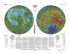
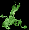
This sheet is one in a series of topographic maps that presents colorcoded topographic data digitally merged with shaded relief data. The figure for the Moon, used for the computation of the map…
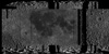
The photomosaic that forms the base for this globe combines a gray-shaded relief airbrush image with color-coded topographic data. The shaded relief data provide interpretations of lunar morphology…
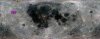
Product Information: This mosaic represents a reduced-resolution version of the empirical calibration Clementine near-infrared (NIR) mosaic processed to 500 meters per pixel (m) spatial resolution…
The Lunar Reconnaissance Orbiter Camera (LROC) consists of one Wide Angle Camera (WAC) for synoptic multispectral imaging and two Narrow Angle Cameras (NAC) that provide high-resolution images (0.5…
Planetary nomenclature, like terrestrial nomenclature, is used to uniquely identify a feature on the surface of a planet or satellite so that the feature can be easily located, described, and…
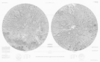
Product Information: This near-global mosaic was generated using data from the SELenological and Engineering Explorer (SELENE) “Kaguya” Terrain Camera (TC) instrument. TC source data originated…