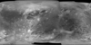
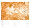
This global map base of Ganymede utilizes the best image quality and moderate resolution coverage supplied by Galileo SSI (Solid State Imaging instrument) and Voyager 1 and 2. The image processing…
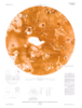
Planetary nomenclature, like terrestrial nomenclature, is used to uniquely identify a feature on the surface of a planet or satellite so that the feature can be easily located, described, and…
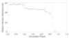
The Io occultation lightcurve dataset consists of observations of Io while it is in eclipse and being occulted by Jupiter. The observations are obtained in the L’ prime (3.5 micron) band at the…
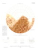
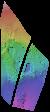
Product Information: This uncontrolled Digital Elevation Model (DEM) was created to investigate the terrain of the Tvashtar Paterae volcanic region on Io, using stereo imagery from the Galileo…