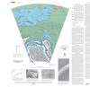
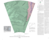
Introduction The polar deposits on Mars probably record martian climate history over the last 107 to 109 years (for example, Thomas and others, 1992). The area shown on this map includes layered…
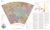
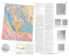
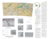
INTRODUCTION This geologic map of the Hellas region focuses on the stratigraphic, structural, and erosional histories associated with the largest well-preserved impact basin on Mars. Along with the…
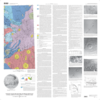
This map uses Viking Orbiter image data and Viking 1 Lander image data to evaluate the geologic history of a part of Chryse Planitia, Mars. The map area lies at the termini of the Maja and Kasei…
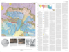
Introduction The Lavinia Planitia quadrangle (V-55) is in the southern hemisphere of Venus and extends from 25 to 50 south latitude and from 330 to 360 longitude. It covers the central and northern…
The Galaxias region (MTM 35217) is one of a series of 1:500,000-scale science study areas on Mars sponsored by NASA's Planetary Geology and Geophysics Program. Situated near the northern limit of…
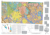
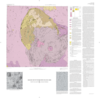
The geologic map of Ophir and central Candor Chasmata is one of a series of 1:500,000 scale maps prepared for areas on Mars that are of particular scientific interest and may serve as potential…
The polar deposits on Mars are of great interest because they probably record martian climate variations (Thomas and others, 1992). The area shown on this map includes polar layered deposits with…
The geology for this map was compiled using Viking Orbiter images on 1:500,000- scale photomosaics of the Mars Transverse Mercator quadrangles -40262, -40267, and -40272. This map represents a…
The geologic map shows lava flows and fan-shaped deposits on Pavonis Mons, the central of three large shield volcanoes (Arsia, Pavonis, and Ascraeus Montes) that form the Tharsis Montes volcanic…