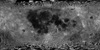
Product Information: This near-global mosaic was generated using data from the SELenological and Engineering Explorer (SELENE) “Kaguya” Terrain Camera (TC) instrument. TC source data originated…
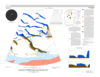
The Ice Favorability Index (IFI) maps below are based on a geologic system model for ice deposition and evolution (Cannon and Britt 2020). The index maps are predictive, not based on surface ice…
Planetary nomenclature, like terrestrial nomenclature, is used to uniquely identify a feature on the surface of a planet or satellite so that the feature can be easily located, described, and…
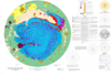
The north polar region of Mars occurs within the central and lowest part of the vast northern plains of Mars and is dominated by the roughly circular north polar plateau, Planum Boreum. The northern…
The north polar region of Mars is dominated by Planum Boreum, a roughly circular, domical plateau that rises >2,500 m above the surrounding lowland. Planum Boreum is >1,500 km in diameter, contains…
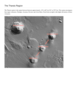
Hellas Planitia comprises the floor deposits of the Hellas basin, more than 2,000 km across and 8 km deep, which is located in the southern hemisphere's cratered highlands and is the largest…
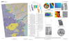
Deuteronilus Mensae, first defined as an albedo feature at lat 35.0 deg N., long 5.0 deg E., by U.S. Geological Survey (USGS) and International Astronomical Union (IAU) nomenclature, is a gradational…
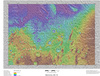
Mars Transverse Mercator (MTM) -20012 and -25012 quadrangles (lat 17.5 deg - 27.5 deg S., long 345 deg - 350 deg E.) cover a portion of Margaritifer Terra near the east end of Valles Marineris. The…