Products

1000 Results Collapse
Mars MGS MOLA - MEX HRSC Blended Shaded Relief 200m v2 thumbnail

Mars MGS MOLA - MEX HRSC Blended Shaded Relief 200m v2

application/octet-stream 1 kB

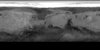
This is a shaded relief of the original DEM described next. This data product, now at version 2, is a blend of digital elevation model (DEM) data derived from the Mars Orbiter Laser Altimeter (MOLA),…

Mars MGS MOLA Global Color Shaded Relief 463m v1 thumbnail

Mars MGS MOLA Global Color Shaded Relief 463m v1

application/isis 3 GB

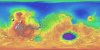
Product Information: This map is based on data from the Mars Orbiter Laser Altimeter (MOLA) (Smith, et al., 2001), an instrument on NASA’s Mars Global Surveyor (MGS) spacecraft (Albee, et al.,…

Moon LROC WAC GLD100 ColorShade 79S79N 118m v1 thumbnail

Moon LROC WAC GLD100 ColorShade 79S79N 118m v1

application/isis 10 GB

Product Information: This product represents a near-global lunar topography from stereo image data acquired by the Wide-angle Camera (WAC) of the Lunar Reconnaissance Orbiter Camera (LROC) system…

Moon SELENE Kaguya TC Evening Global Mosaic 474m v4 thumbnail

Moon SELENE Kaguya TC Evening Global Mosaic 474m v4

application/isis 506 MB

Product Information: This near-global mosaic was generated using data from the SELenological and Engineering Explorer (SELENE) “Kaguya” Terrain Camera (TC) instrument. TC source data originated…

Moon SELENE Kaguya TC Evening Global Mosaic 474m v2 thumbnail

Moon SELENE Kaguya TC Evening Global Mosaic 474m v2

application/isis 506 MB

Product Information: This near-global mosaic was generated using data from the SELenological and Engineering Explorer (SELENE) “Kaguya” Terrain Camera (TC) instrument. TC source data originated…

Moon SELENE Kaguya TC Global Orthomosaic 474m v2 thumbnail

Moon SELENE Kaguya TC Global Orthomosaic 474m v2

application/isis 506 MB

Product Information: This near-global mosaic was generated using data from the SELenological and Engineering Explorer (SELENE) “Kaguya” Terrain Camera (TC) instrument. TC source data originated…

Moon Apollo Lunar Sample Photographs thumbnail

Moon Apollo Lunar Sample Photographs

text/xml 7 kB

Product Information: This set of archive volumes contains digital scanned versions of original film photographs of rock, soil, and core samples collected from the lunar surface during the Apollo 11,…

Mars Year 24-28 MOC WA Red and Blue 2023 thumbnail

Mars Year 24-28 MOC WA Red and Blue 2023

application/pds-lab 168 kB

NASA's Mars Global Surveyor spacecraft contained the Mars Orbiter Camera, which had a wide-angle (MOC-WA) system sensitive to narrow, 50 nm-wide ranges of purple ('blue') and orange ('red') light. …

Regional Topography and Photometric Cube Data for Lunar Locations thumbnail

Regional Topography and Photometric Cube Data for Lunar Locations

application/isis 779 kBMay 15 2023

This archive contains topography and photometric data generated by the Gaskell Stereophotoclinometry (SPC) software suite. It focuses on six regions on the Moon. These include wrinkle ridges at Dorsa…

Lunar M3 Water Map PDS4 Archive thumbnail

Lunar M3 Water Map PDS4 Archive

image/tiff 4 kBDec 22 2022

These water maps and their ancillary data were prepared for studying the effects of Earth's magnetotail on the formation of the lunar surface water by Dr. Shuai Li at University of Hawaii. It is…

Project Pages

22 Results Collapse

Documents

75 Results Collapse
ISPRS 2004 Topographic Mapping of Mars from Hectometer to Micrometer Scales thumbnail

ISPRS 2004 Topographic Mapping of Mars from Hectometer to Micrometer Scales

application/pdf 2 MB

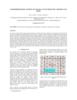
We describe USGS topomapping of Mars at resolutions from 100 m to 30 µm with data from the latest spacecraft missions. Analysis of NASA 2001 Mars Odyssey Thermal Emission Imaging System (THEMIS)…

ISPRS 2004 Performance of Automatic Tie Point Extraction using HRSC Imagery of the Mars Express Mission thumbnail

ISPRS 2004 Performance of Automatic Tie Point Extraction using HRSC Imagery of the Mars Express Mission

application/pdf 340 kB

In January 2004 the first European interplanetary spacecraft, Mars Express, was inserted successfully into a Martian orbit. The multiline scanner HRSC (High Resolution Stereo Camera) on board of…

ISPRS 2004 Landing Site Mapping and Rover Localization for the 2003 Mars Exploration rover Mission: Technology and Experimental Results thumbnail

ISPRS 2004 Landing Site Mapping and Rover Localization for the 2003 Mars Exploration rover Mission: Technology and Experimental Results

application/pdf 73 kB

This paper presents the technology and experimental results for high-precision landing-site mapping and rover localization developed for the ongoing 2003 Mars Exploration Rover (MER) mission. This…

ISPRS 2004 Automation in Mars Landing-Site Mapping and Rover Localization thumbnail

ISPRS 2004 Automation in Mars Landing-Site Mapping and Rover Localization

application/pdf 603 kB

Our project aims to automate Mars mapping and localization using robotic stereo and descent imagery. Stereo vision is a wellstudied domain. However, most efforts aim only at a general scene; little…

ISPRS 2004 Geomorphometric Mapping of Grand Canyon from the 1-Degree USGS DEMs thumbnail

ISPRS 2004 Geomorphometric Mapping of Grand Canyon from the 1-Degree USGS DEMs

application/pdf 946 kB

In a previous research effort a terrain partition framework was defined allowing the partition of the landscape of Valles Marineris chasma (an elongated steep-sided depression located in Mars) to…

ISPRS 2004 True-3D Visualization of the Martian Surface Based on Lenticular Foil Technology using HRSC Imagery thumbnail

ISPRS 2004 True-3D Visualization of the Martian Surface Based on Lenticular Foil Technology using HRSC Imagery

application/pdf 389 kB

Following the conceptual idea "from 3D camera to 3D view", the production of true-3D image maps for the glasses-free stereoviewing of parts of the Martian surface, is described. The image data have…

ISPRS 2004 Some Aspects of Multilingual Planetary Map Producing for Non-Professional Audience: Visualization and Nomenclature thumbnail

ISPRS 2004 Some Aspects of Multilingual Planetary Map Producing for Non-Professional Audience: Visualization and Nomenclature

application/pdf 565 kB

In general, maps should answer a very simple question of its reader: "what's there" and „where is something”? For planetary maps, the answer is more difficult, because (1) in some cases even map…

ISPRS 2004 Digital Cartography with HRSC on Mars Express thumbnail

ISPRS 2004 Digital Cartography with HRSC on Mars Express

application/pdf 8 MB

The High Resolution Stereo Camera (HRSC) on board of the European space mission Mars Express provides multispectral digital image data in high resolution as well as the systematic stereo coverage of…

Meteor Crater Abstract LPSC 43 thumbnail

Meteor Crater Abstract LPSC 43

application/pdf 343 kB

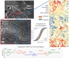
CHARACTERIZATION OF IMPACT EJECTA DEPOSITS FROM METEOR CRATER, ARIZONA. T. A. Gaither, J. J. Hagerty, J. F. McHone, and H. E. Newsom, U.S. Geological Survey, Astrogeology Science Center, 2255 N.…

Meteor Crater Abstract LPSC 42 thumbnail

Meteor Crater Abstract LPSC 42

application/pdf 225 kB

MULTI-DIMENSIONAL CHARACTERIZATION OF IMPACT EJECTA DEPOSITS FROM METEOR CRATER, AZ. T. A. Gaither, J. J. Hagerty, S. E. Clark, T. M. Hare, R. K. Hayward, H. E. Newsom, S. P. Wright, and J. McHone,…