Products

244 Results Collapse
Imaging Node Status, Mar10 thumbnail

Imaging Node Status, Mar10

application/vnd.openxmlformats-officedocument.presentationml.presentation 1 MB

How the Geosciences Node is helping active missions make their conversion plans thumbnail

How the Geosciences Node is helping active missions make their conversion plans

application/vnd.openxmlformats-officedocument.presentationml.presentation 471 kB

PDS4 Change Control Board Status report thumbnail

PDS4 Change Control Board Status report

application/vnd.openxmlformats-officedocument.presentationml.presentation 54 kB

Moon LRO South Pole DEM Verification and Validation Report thumbnail

Moon LRO South Pole DEM Verification and Validation Report

application/pdf 3 MB

This report describes a Digital Elevation Model (DEM) generated from Lunar Reconnaissance Orbiter Camera (LROC) Narrow Angle Cameras (NAC) stereo pairs over the lunar south pole and provides a…

FY 2019 Budget Request (PPBE) to Planetary Science Director thumbnail

FY 2019 Budget Request (PPBE) to Planetary Science Director

application/vnd.openxmlformats-officedocument.presentationml.presentation 67 kB

Tool Working Group thumbnail

Tool Working Group

application/vnd.openxmlformats-officedocument.presentationml.presentation 190 kB

State of the IPDA 2018 thumbnail

State of the IPDA 2018

application/vnd.openxmlformats-officedocument.presentationml.presentation 11 MB

GIS Data in PDS4 thumbnail

GIS Data in PDS4

application/vnd.openxmlformats-officedocument.presentationml.presentation 2 MB

Imaging Node Status, Mar10 thumbnail

Imaging Node Status, Mar10

application/vnd.openxmlformats-officedocument.presentationml.presentation 214 kB

Web Site Expressions of the PDS Focus thumbnail

Web Site Expressions of the PDS Focus

application/vnd.openxmlformats-officedocument.presentationml.presentation 8 MB

Project Pages

2 Results Collapse

Documents

180 Results Collapse
ISPRS 1998 Status of the RAND Control Network of Mars thumbnail

ISPRS 1998 Status of the RAND Control Network of Mars

application/pdf 90 kB

The RAND control network of Mars was begun during the Mariner 9 mission, and it has been expanded and improved since then. The network is based on measurements of points made on images taken by the…

ISPRS 1998 Digital Topographic Mapping of Mercury thumbnail

ISPRS 1998 Digital Topographic Mapping of Mercury

application/pdf 64 kB

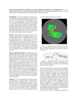
We describe a cartographic project to re-process and semi-automatically stereo match Mariner 10 vidicon stereo pair images. Three different patch-based digital stereo matching algorithms have been…

ISPRS 1998 New Map Products from Planet Mars thumbnail

ISPRS 1998 New Map Products from Planet Mars

application/pdf 63 kB

The map sheet "MARS 1:2,000,000 Mouth of Ares and Tiu Valles" presents the mapped area on the planet's northern hemisphere in two different cartographic categories. The Image Map, portraying the…

ISPRS 1998 Getting to know SPICE thumbnail

ISPRS 1998 Getting to know SPICE

application/pdf 62 kB

The SPICE ancillary information system developed at NASA's Jet Propulsion Laboratory offers a flexible, multimission suite of data containers and related software--a subroutine library--for…

ISPRS 1999 Assessment of Published Viking Orbiter DEMs derived from Stereo Photogrammetry using MOLA Data thumbnail

ISPRS 1999 Assessment of Published Viking Orbiter DEMs derived from Stereo Photogrammetry using MOLA Data

application/pdf 2 MB

Described the exciting results which have been obtained from the initial set of mainly Northern hemispheric laser altimetry tracks from the MOLA instrument known as the SPO-1 phase. More recently has…

ISPRS 1999 Triaxial Ellipsoid as a Reference-Surface on Mars Mapping thumbnail

ISPRS 1999 Triaxial Ellipsoid as a Reference-Surface on Mars Mapping

application/pdf 59 kB

At the development of a mathematical basis of cartographic products the problems of selection of a reference-surface system, system of coordinates, and also selection and elaboration of cartographic…

ISPRS 1999 Revision of the Mars Control Net and Global Digital Image Mosaic thumbnail

ISPRS 1999 Revision of the Mars Control Net and Global Digital Image Mosaic

application/pdf 31 kB

In the late 1980s, the USGS, Flagstaff, produced the first in what would become a series of very large, global digital image mosaics of solar system bodies. This Mars mosaicked digital image model…

ISPRS 1999 A Database of Viking Orbiter Image Coverage of Mars for Cartographic and Scientific Use thumbnail

ISPRS 1999 A Database of Viking Orbiter Image Coverage of Mars for Cartographic and Scientific Use

application/pdf 2 MB

Viking Orbiters 1 and 2 collectively returned more than 46,000 images of Mars between 1976 and 1980. Numerous observation sequences with different objectives resulted in an extremely complex and…

ISPRS 1999 USGS Mapping of the Mars Pathfinder Landing Site: Progress and Plans thumbnail

ISPRS 1999 USGS Mapping of the Mars Pathfinder Landing Site: Progress and Plans

application/pdf 112 kB

This abstract describes progress in cartographic processing of data from the Imager for Mars Pathfinder (IMP) by the U. S. Geological Survey in the past year, and plans for advanced cartographic…

ISPRS 1999 Stereogrammetric Mapping on Mars: Promise, Progress, and Problems thumbnail

ISPRS 1999 Stereogrammetric Mapping on Mars: Promise, Progress, and Problems

application/pdf 46 kB

To assist in landing site selection, we are compiling a suite of stereo images of potential landing sites for the 1998 and 2001 Mars landers. From these, we are using automated stereogrammetry…