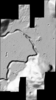
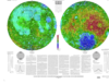
This is a shaded-relief of the digital elevation model (DEM) extracted from the Lunar Reconnaissance Orbiter Camera (LROC) Narrow Angle Camera (NAC) stereo images from the Lunar Reconnaissance…
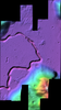
This is a slope-colorized shaded-relief of the digital elevation model (DEM) extracted from the Lunar Reconnaissance Orbiter Camera (LROC) Narrow Angle Camera (NAC) stereo images from the Lunar…
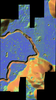
This is a colorized shaded-relief of the digital elevation model (DEM) extracted from the Lunar Reconnaissance Orbiter Camera (LROC) Narrow Angle Camera (NAC) stereo images from the Lunar…
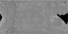
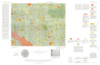
This is a visible image mosaic generated using Lunar Reconnaissance Orbiter Camera (LROC) Narrow Angle Camera (NAC) images from the Lunar Reconnaissance Orbiter mission. The images were…
This is a digital elevation model (DEM) extracted from the Lunar Reconnaissance Orbiter Camera (LROC) Narrow Angle Camera (NAC) stereo images from the Lunar Reconnaissance Orbiter mission. The…
Product Information: This Lunar Orbiter (LO) mosaic of the Moon was constructed using photographs acquired by LO III, IV and V. Work towards constructing the global mosaic spanned over seven years.…
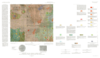
This publication is a set of three sheets of topographic maps that presents color-coded topographic data digitally merged with shaded relief data. Adopted figure: The figure for the Moon, used for…