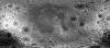
Product Information: This product represents a near-global lunar topography from stereo image data acquired by the Wide-angle Camera (WAC) of the Lunar Reconnaissance Orbiter Camera (LROC) system…
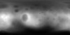
Product Information: Images from the European Space Agency's High Resolution Stereo Camera (HRSC) aboard the Mars Express were used to obtain 3-dimensional coordinates of surface points of Phobos.…
This is a shaded relief of the original DEM described next. This data product, now at version 2, is a blend of digital elevation model (DEM) data derived from the Mars Orbiter Laser Altimeter (MOLA),…
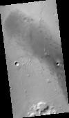
This product represents an orthorectified CTX image within part of a candidate landing site for the Mars2020 mission. The CTX image from which this product was derived is one member of a stereopair.…
This product represents adirectional topographic slopes over 20 meter horizontal baselines within part of a candidate landing site for the Mars2020 mission. The slope map was derived from a CTX-based…
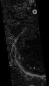
This digital terrain model (DTM) was produced as part of an effort to characterize topography within candidate landing ellipses for the Mars2020 mission and to aid entry, descent, and landing…