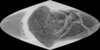
This image mosaic is one of several products created as the first step of cartography planning in support of the Cassini-Huygens Mission to Saturn & Titan. The data included in this mosaic were…
These files are part of the Global Topographic Data Record (GTDR) series of Digital Map Products (DMP) produced by the Cassini RADAR Science Team. They contain a variety of different models for the…
This 2.5D shape model of Enceladus was generated by interpolating the associated 3D point cloud of latitude, longitude, radius values, minus the mean radius of Enceldaus (251500 meters), to a regular…
This 2.5D topographic model of Enceladus was created by first generating a fully 3D shape (radius) model from a dense network of image tie points and photogrammetrically solving for point latitude,…
Product Information: This mosaic represents the completion of a global control network of Enceladus containing Cassini Imaging Science Subsystem (ISS) images. A total of 586 images in CLR, GRN, UV3,…
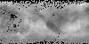
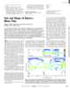
Product Information: This global digital map of Saturn's moon Titan was created using images taken by the Cassini spacecraft's Imaging Science Subsystem (ISS). The map was produced in June 2015…
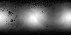
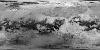
Product Information: This global map of Titan is a preliminary product showing coverage from Synthetic Aperture Radar (SAR) and High Altitude Synthetic Aperture Radar (HiSAR) images at a pixel…
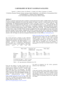
We have re-measured control points and re-computed a control point network for Saturn’s satellite Dione. Our network is based on 16 images (obtained by the narrow-angle cameras of Voyager I and…
The Cassini spacecraft will begin its tour through the Saturnian system in July 2004. One major goal of the imaging instrument aboard Cassini is to complete the global coverage of the icy Saturnian…
Cassini observations show that Saturn’s moon Titan is slightly oblate. A fourth-order spherical harmonic expansion yields north polar, south polar, and mean equatorial radii of 2574.32 T 0.05…