Ortho mosaic of loose rock clast based on the digital elevation model
Digital elevation model of rock
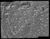
Ortho mosaic of rock based on the digital elevation model
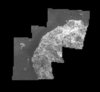
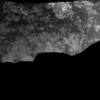
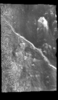
Image mosaic of cliff and soil
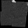
Image mosaic of soil
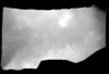
Pre-MB image mosaic of soil
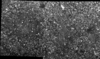
Ortho mosaic of soil based on the digital elevation model
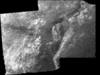
Post-MB image mosaic of rock
Post-RAT brush ortho mosaic of rock based on the digital elevation model
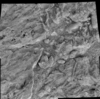
Post-RAT image mosaic of rock
Formulas of transformation between coordinates on image plane, planetocentric coordinates and photometric conditions of observation for arbitrary planet have been obtained. An example with…
After the initial proposal of Contact 1 and 2, previously published papers about ocean on Mars can basically be divided in two groups. The first one was based on shorelines theory, however,…
Many indicators for ocean on Mars were proposed: outflow channels and features related to the evolution of standing bodies of water (polygons, lobate impact craters), features consistent with the…
The Mars Transverse Mercator (MTM) Map Series has been used to publish geologic and controlled photomosaic maps of Mars since 1984. Traditionally maps were published using planetographic coordinates…
One of the primary tasks of the Mars Global Surveyor (MGS) mission is to produce precision mapping products over the Mars surface [Albee et al, 2001]. Properties and capabilities of MOC NA (Mars…
After GUI was spread, we have to deal with huge sized programs written for investigation of planetary data. There are many commercial based utilities to make those smaller such that GUI libraries or…
Recently, mathematical approach was proposed providing a way to compute how deep Martian ocean was during each period of the planet history, including the probability that ocean existed once. An…
Recently, mathematical approach was proposed providing a way to compute how deep Martian ocean was during each period of the planet history, including the probability that ocean existed once.…
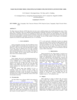
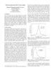
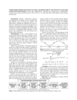
This paper presents techniques for automatic mapping of Mars landing sites using surface-based images, i.e., those taken by Mars landers and/or rovers. An innovative method for automatic tie point…
We describe a series of programs and scripts under development for the USGS digital cartography and image processing software system ISIS that will make it possible for users to create digital…