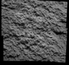
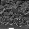
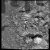
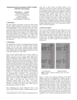
Post-RAT brush image mosaic of rock
Post-MB ortho mosaic of rock based on a Triangulated Irregular Network (TIN)
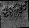
Post-RAT brush and Pre-MB image mosaic of outcrop
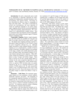
Pre-MB digital elevation model of vesicular basalt
Pre-MB ortho mosaic of vesicular basalt based on the digital elevation model
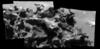
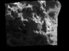
Post-MB image mosaic of rock
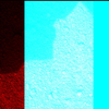
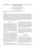
Pre-MB anaglyph of soil
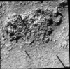
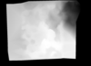
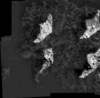
Pre-MB image mosaic of soil
The stereo photogrammetric observable equations are presented relating control point image location to camera distortions, camera pointing, spacecraft position, Mars-fixed areocentric control point…
NASA's Mars Geodesy/Cartography Working Group (MGCWG), established in 1998 and chaired since 2000 by one of us (TCD), consists of leading researchers in planetary geodesy and cartography at such…
Though the primary focus at Malin Space Science Systems (MSSS) is on building and operating instruments through the archiving of raw data, we have also pursued research interests in planetary…
A basic requirement for the planning of future Mars missions are precise and high resolution maps, especially, of the landing site area. We present a new digital orthoimage map of Mars using data…
The current Mars Global Survey (MGS) mission has been collecting high resolution digital images (MOC) and laser ranges (MOLA). The processing MOLA range data results in a global digital elevation…
We describe our initial experiences producing controlled digital elevation models (DEMs) of Mars with horizontal resolutions of ≤10 m and vertical precisions of ≤2 m. Such models are of intense…
The high resolution instruments on board the Mars Global Surveyor (MGS) provide the necessary data to survey the Martian topographic surface in the finest detail so far [Albee, et al, 2002]. However,…
On such a volcanically active world as Io, topography is especially important for understanding lava emplacement, mountain formation, internal dynamics, and volcanic history. Previously we have…
In this paper we focus on a detail concerning the estimation of exterior orientation parameters of the High Resolution Stereo Camera (HRSC) orbiting planet Mars during the European Mars Express…