This product has been superseded by Magellan Global Topography 4641m v02 (1997). Global Topographic Data Record (GTDR). The range to surface is derived by fitting altimeter echoes from the fan-beam…
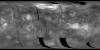
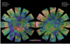
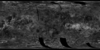
The images used for the base of this globe show the northern and southern hemispheres of Venus as revealed by more than a decade of radar investigations culminating in the 1990-1994 Magellan mission.…
Product Information: Global Reflectivity Data Record (GREDR). The power reflection coefficients are derived by fitting altimeter echoes from the fan-beam altimetry antenna as a function of time to…
Product Information: This Global Emissivity Data Record (GEDR) includes all Magellan measurements in which the high-gain antenna followed the nominal look-angle profile, in which the observed…
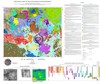
We present a GIS package for the 1:2,500,000 geological map of the Alpha Regio (V-32) quadrangle, Venus. The V-32 quadrangle extends from 0° to 25 S, 0°to 30° E with an area of approximately…
Product Information: In this Global Slope Data Record (GSDR) the surface meter-scale slopes are derived by fitting altimeter echoes from the fan-beam altimetry antenna as a function of time to…
The Magellan spacecraft went into Venus orbit in 1990 and by 1992 had made three complete cycles of polar orbits, each cycle covering the full range of longitudes. During this time the spacecraft…
This page has been created as part of a project to put planetary control networks on the web. This control network for Venus originated from Merton Davies, Tim Colvin and others, and was provided to…