
Venus_Magellan_RAND_control_network.zip
This page has been created as part of a project to put planetary control networks on the web. This control network for Venus originated from Merton Davies, Tim Colvin and others, and was provided to the USGS in 1997. The control network solution was originally performed with software developed at Rand, and documented by Colvin (1990). Each control network is essentially a set of radargrammetric solution (input and output) files. The input files consist of, aside from a priori information, measurements of common points (control points, sometimes called tie points) on images of RADAR strips produced by Magellan. The output files include the body coordinates of the control points in latitude, longitude, and radius, and revised orientation information (camera pointing) for the images. The primary use of such information is for the creation of image mosaics of the planetary body. However, these solutions can also provide fundamental data on the size and shape of the body, its rotation period, and the direction of its polar axis in space. The control point coordinates also usually serve as a coordinate reference frame that defines the fundamental coordinate reference system for the body in question. Formatting of this control network data for Venus has yet to be updated for compatibility with the USGS ISIS2 and ISIS3 cartography software There are two RAND control network available here covering the northern and southern hemispheres (Davies et al., 1992). This release is comprised of data from original RAND control network solutions from the Venus RADAR Mapper onboard the Magellan spacecraft.
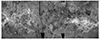
Image Description:
This global mosaic of Venus utilizes the best radar data supplied by the Magellan spacecraft. Cartographic processing was performed by USGS in 1997 using datasets produced by JPL.
- Mimetype
- application/zip
- Filename
- Venus_Magellan_RAND_control_network.zip
- Author
- Brent Archinal
- Originator
- USGS Astrogeology Science Center
- Added to Astropedia
- 12 December 2018
- Modified
- 16 July 2021
General
- Purpose
Created as part of a project to put planetary geodesy control networks on the web. These control network data were originally provided by Merton Davies and Tim Colvin of the RAND Corporation. Funds were provided for a conversion and archiving effort by the NASA Planetary Geology and Geophysics Program and the NASA Cartography Program.
- Geospatial Data Presentation Form
- Control Network
- Native Data Set Environment
- ISIS v2
Keywords
- Target
- Venus
- Theme
- Control Network
- Mission
- Magellan
Contact and Distribution
- Access Instructions
Contained in the ZIP file are the necessary data to open the RAND solution of the Venus control network in its original RAND solution format.
Venus_data.zip Contents:
xmea.dat – RAND solution image measurements (mm) input file.
xout.dat – RAND solution “poles, points, and positions” output file.
xpar.dat – RAND solution program operation control input file.
xche.dat – RAND solution residual output file.
Documentation and Information:
ISIS-PG-FMT501_parXX_dat – Description of format of file xpar.dat (in PDF format).
ISIS-PG-FMT502_outXX_dat – Description of format of file xinp.dat (in PDF format).
ISIS-PG-FMT503_meaXX_dat – Description of format of file xmea.dat (in PDF format).
ISIS-PG-FMT511_che3XX_dat – Description of format of file xche.dat (in PDF format).
Data Status and Quality
- Completeness Report
This is a global control network of Venus, and incorporates most of the usable images from the Magellan mission.
- Process Description
RAND solution files are provided as *.dat files. The conversion to ISIS2 match point format (.mat) was performed in 2003 without making corrections or adjustments to the network.
Lineage
- Source Originator
- Rand
- Source Title
- The rotation period, direction of the North Pole, and geodetic control network of Venus
- Source Online Linkage
- https://agupubs.onlinelibrary.wiley.com/doi/abs/10.1029/92JE01166
- Type of Source Media
- Online
Geospatial Information
- Direct Spatial Reference Method
- Point
- Horizontal Coordinate System Units
- Degrees


