Positional control for MDIM 2.1 comes from a new geodetic/photogrammetric solution of the global Mars Mariner 9 and Viking image control network. The details of this network solution are described…
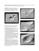
Viking Orbiter, MOC and MOLA data are being used to construct three dimensional landmark templates on Mars which can be aligned with a variety of data types for navigation on future missions and…
We present a new global map of Mars based on images taken by the Viking Orbiters. Precise image position information and camera pointing data, needed to produce this map, were derived from a recent…
Viking Orbiters 1 and 2 collectively returned more than 46,000 images of Mars between 1976 and 1980. Numerous observation sequences with different objectives resulted in an extremely complex and…
Described the exciting results which have been obtained from the initial set of mainly Northern hemispheric laser altimetry tracks from the MOLA instrument known as the SPO-1 phase. More recently has…
We recomputed the Viking Mars Control Point Network and derived Mars-fixed 3-dimensional coordinates of 3739 selected, globally distributed landmarks. The Mars Pathfinder coordinates and data from…
The Viking Orbiters acquired quality stereo coverage of a significant fraction of Mars in 1976-1980. Several groups have been using this stereo coverage to produce global and regional scale…
The current global spatial control net of Mars provides the geodetic basis for an orthoimage map composed of image data sets obtained from VIKING missions from 1976 to 1980. This map is not…