Download
- Original (pdf) 47 kB
ISPRS 2003 Topography Profile Diagrams of Mars: Algorithms for Computing Altitude of Craters
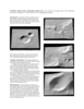
Recently, mathematical approach was proposed providing a way to compute how deep Martian ocean was during each period of the planet history, including the probability that ocean existed once. An important step toward the formal proof of Martian ocean recession, timing and probability is representation of Martian topography and related values, in the form of topography profile diagrams. For this purpose, algorithms for computing crater altitude according to the topography, center coordinates and radius of impact crater r are of importance.
- Mimetype
- application/pdf
- Filename
- Nezic_2_isprs_mar03.pdf
- Publisher
- ISPRS
- Author
- gsc
- Originator
- Z. Nežić, G. Salamunićcar
- Group
- Astrogeology
- Added to Astropedia
- 14 May 2012
- Modified
- 9 July 2013
General
- Geospatial Data Presentation Form
- Document
Keywords
- System
- Mars
- Target
- Mars
- Theme
- Topography, Craters
Geospatial Information
- Quad Name