Products

180 Results Collapse
ISPRS 2003 Automatic Mars Landing Site Mapping using Surface-Based Images thumbnail

ISPRS 2003 Automatic Mars Landing Site Mapping using Surface-Based Images

application/pdf 1 MB

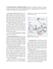
This paper presents techniques for automatic mapping of Mars landing sites using surface-based images, i.e., those taken by Mars landers and/or rovers. An innovative method for automatic tie point…

ISPRS 2003 A Virtual Observatory of Planetary Surfaces thumbnail

ISPRS 2003 A Virtual Observatory of Planetary Surfaces

application/pdf 676 kB

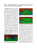
Study of the origin, composition and alteration of planetary regoliths and soils is a key to set constraints on the formation and evolution of telluric planets. Surfaces are indeed complex interfaces…

ISPRS 2003 Impact Crater Detection on Optical Images and DEMs thumbnail

ISPRS 2003 Impact Crater Detection on Optical Images and DEMs

application/pdf 638 kB

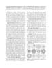
Impact craters are crucial landmarks for geodetic control as well as being interesting geological research targets themselves. Several methods have been developed to automatically detect impact…

ISPRS 2003 Topographic Profile Diagrams of Mars: Architecture of the Density of Craters Curver Low-Pass Filter thumbnail

ISPRS 2003 Topographic Profile Diagrams of Mars: Architecture of the Density of Craters Curver Low-Pass Filter

application/pdf 48 kB

Recently, mathematical approach was proposed providing a way to compute how deep Martian ocean was during each period of the planet history, including the probability that ocean existed once.…

ISPRS 2003 Topography Profile Diagrams of Mars: Algorithms for Computing Altitude of Craters thumbnail

ISPRS 2003 Topography Profile Diagrams of Mars: Algorithms for Computing Altitude of Craters

application/pdf 47 kB

Recently, mathematical approach was proposed providing a way to compute how deep Martian ocean was during each period of the planet history, including the probability that ocean existed once. An…

ISPRS 2003 Mars for Plan 9 thumbnail

ISPRS 2003 Mars for Plan 9

application/pdf 516 kB

After GUI was spread, we have to deal with huge sized programs written for investigation of planetary data. There are many commercial based utilities to make those smaller such that GUI libraries or…

ISPRS 2003 DEM Generation from MGS NA Stereo Images thumbnail

ISPRS 2003 DEM Generation from MGS NA Stereo Images

application/pdf 74 kB

One of the primary tasks of the Mars Global Surveyor (MGS) mission is to produce precision mapping products over the Mars surface [Albee et al, 2001]. Properties and capabilities of MOC NA (Mars…

ISPRS 2003 Voyager Base Maps of the Icy Saturnian Satellites thumbnail

ISPRS 2003 Voyager Base Maps of the Icy Saturnian Satellites

application/pdf 2 MB

The Cassini spacecraft will begin its tour through the Saturnian system in July 2004. One major goal of the imaging instrument aboard Cassini is to complete the global coverage of the icy Saturnian…

ISPRS 2003 Mars Transverse Mercator (MTM) Map Series Updated with Planetocentric Grid thumbnail

ISPRS 2003 Mars Transverse Mercator (MTM) Map Series Updated with Planetocentric Grid

application/pdf 131 kB

The Mars Transverse Mercator (MTM) Map Series has been used to publish geologic and controlled photomosaic maps of Mars since 1984. Traditionally maps were published using planetographic coordinates…

ISPRS 2003 Surface Age Conputations for Mars: A Step Toward the Formal Proof of Martian Ocean Recession, Timing and Probability. thumbnail

ISPRS 2003 Surface Age Conputations for Mars: A Step Toward the Formal Proof of Martian Ocean Recession, Timing and Probability.

application/pdf 134 kB

Many indicators for ocean on Mars were proposed: outflow channels and features related to the evolution of standing bodies of water (polygons, lobate impact craters), features consistent with the…

Project Pages

2 Results Collapse

Documents

180 Results Collapse
ISPRS 2001 High Precision Landing Site Mapping and Rover Localization by Integrated Bundle Adjustment of Ground-Based Image Data thumbnail

ISPRS 2001 High Precision Landing Site Mapping and Rover Localization by Integrated Bundle Adjustment of Ground-Based Image Data

application/pdf 10 kB

High precision topographic information from all available data is critical to many landing site geological and engineering applications. Meanwhile, precise navigation and localization of the rover is…

ISPRS 2001 High Resolution Digital Elevation Models of Mars from MOC Narrow Angle Stereoimages thumbnail

ISPRS 2001 High Resolution Digital Elevation Models of Mars from MOC Narrow Angle Stereoimages

application/pdf 296 kB

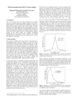
In this abstract we report on our initial experiences performing stereotopographic mapping of Mars with high-resolution images from the Mars Global Surveyor Mars Orbiter Camera Narrow-Angle subsystem…

ISPRS 2001 Validation of the USGS Sensor Model for Topographic Mapping of Venus Using Magellan Radar Stereoimagery thumbnail

ISPRS 2001 Validation of the USGS Sensor Model for Topographic Mapping of Venus Using Magellan Radar Stereoimagery

application/pdf 986 kB

The Magellan spacecraft went into Venus orbit in 1990 and by 1992 had made three complete cycles of polar orbits, each cycle covering the full range of longitudes. During this time the spacecraft…

ISPRS 2001 Improved 3D Mars Control Net from a Combined Adjustment of Viking Images and Mars Orbiter Laser Altimeter Data thumbnail

ISPRS 2001 Improved 3D Mars Control Net from a Combined Adjustment of Viking Images and Mars Orbiter Laser Altimeter Data

application/pdf 44 kB

The current global spatial control net of Mars provides the geodetic basis for an orthoimage map composed of image data sets obtained from VIKING missions from 1976 to 1980. This map is not…

ISPRS 2001 Lunar Orbiter Digitization and Cartographic Processing thumbnail

ISPRS 2001 Lunar Orbiter Digitization and Cartographic Processing

application/pdf 377 kB

Digitization and cartographic processing of 5 Lunar Orbiter (LO) IV frames (109H, 110H, 114H, 115H, and 114M) are now complete, and these data are available online at…

ISPRS 2001 Mars Cartography using MOLA Control thumbnail

ISPRS 2001 Mars Cartography using MOLA Control

application/pdf 50 kB

The stereo photogrammetric observable equations are presented relating control point image location to camera distortions, camera pointing, spacecraft position, Mars-fixed areocentric control point…

ISPRS 2001 Mars Godesy / Cartography Working Group Recommendations on Mars Cartographic Constants and Coordinate Systems thumbnail

ISPRS 2001 Mars Godesy / Cartography Working Group Recommendations on Mars Cartographic Constants and Coordinate Systems

application/pdf 57 kB

NASA's Mars Geodesy/Cartography Working Group (MGCWG), established in 1998 and chaired since 2000 by one of us (TCD), consists of leading researchers in planetary geodesy and cartography at such…

ISPRS 2001 Planetary Cartography as MSSS thumbnail

ISPRS 2001 Planetary Cartography as MSSS

application/pdf 3 MB

Though the primary focus at Malin Space Science Systems (MSSS) is on building and operating instruments through the archiving of raw data, we have also pursued research interests in planetary…

ISPRS 2001 Galilean Satellites Mosaics thumbnail

ISPRS 2001 Galilean Satellites Mosaics

application/pdf 33 kB

As a result of imagery returned from the Galileo spacecraft, the Galilean satellites have been the focus of a great deal of scientific research and general public interest. New control networks and…

ISPRS 2001 Improving the Rand-USGS Control Network for IO thumbnail

ISPRS 2001 Improving the Rand-USGS Control Network for IO

application/pdf 2 MB

We present here our current results from photogrammetric triangulation solutions for a control network and reference surface for Jupiter’s moon Io. It is compared to previous such solutions by us…