Products

180 Results Collapse
ISPRS 2003 Evolving Automated Feature Extraction Algorithms for Planetary Science thumbnail

ISPRS 2003 Evolving Automated Feature Extraction Algorithms for Planetary Science

application/pdf 544 kB

Planetary exploration missions have returned a wealth of imagery data over the last 40 years. The problem is how to make best use of it all. Thoroughly analyzing such large datasets manually is…

ISPRS 2003 Cartographic Support to Venglobgek International Project on the General Geologic Mapping of Venus: The Main Outlines thumbnail

ISPRS 2003 Cartographic Support to Venglobgek International Project on the General Geologic Mapping of Venus: The Main Outlines

application/pdf 158 kB

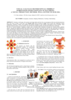
The planet Venus is the second largest (after the Earth) body among the terrestrial-type planets. The surface of Venus is 460x106 km2, which is three times larger than the area of the dry land…

ISPRS 2003 Mass Production of DEMs from MOC Stereo Pairs thumbnail

ISPRS 2003 Mass Production of DEMs from MOC Stereo Pairs

application/pdf 174 kB

In its extended mission, the MGS spacecraft has been operated in so-called "R16" mode, in which a 16-degree pitch is introduced to minimize fuel usage by reducing torque on the spacecraft. This…

ISPRS 2003 Visual Calculus of Perceptual Fribble? World Maps with Constant Scale Edges: A Novel Projection Method, Well-Suited to our Era thumbnail

ISPRS 2003 Visual Calculus of Perceptual Fribble? World Maps with Constant Scale Edges: A Novel Projection Method, Well-Suited to our Era

application/pdf 3 MB

I introduce world maps with constant scale edges [cse], and show how cse encompasses both conventional projections and a new class of maps—world maps with constant scale natural boundaries [csnb].…

ISPRS 2003 A Systematic Approach for Optimizing Spectral and Spatial Matching Between Independent Datasets thumbnail

ISPRS 2003 A Systematic Approach for Optimizing Spectral and Spatial Matching Between Independent Datasets

application/pdf 567 kB

In the field of Earth observation and planetary exploration, a number of spacecrafts have been equipped in the last years with various multispectral and/or hyperspectral optical instruments spanning…

ISPRS 2003 Mapping Mars with Landmark Templates thumbnail

ISPRS 2003 Mapping Mars with Landmark Templates

application/pdf 557 kB

Viking Orbiter, MOC and MOLA data are being used to construct three dimensional landmark templates on Mars which can be aligned with a variety of data types for navigation on future missions and…

ISPRS 2003 Low Resolution Planetary Experiments: Gridding and Mapping Routines using IDL thumbnail

ISPRS 2003 Low Resolution Planetary Experiments: Gridding and Mapping Routines using IDL

application/pdf 211 kB

We present a toolkit of routines for IDL. This toolkit converts a set of coordinates and data sorted by acquisition time into a map. It was developed at first for low-resolution data that require…

ISPRS 2003 Cartography with HRSC on Mars Express thumbnail

ISPRS 2003 Cartography with HRSC on Mars Express

application/pdf 54 kB

The Mars Express mission, which is expected to be launched in May/June 2003, will bring the "High Resolution Stereo Camera" (HRSC) into an orbit around the planet Mars. This research program, which…

ISPRS 2003 GIS 101 for Planetary Research thumbnail

ISPRS 2003 GIS 101 for Planetary Research

application/pdf 156 kB

GIS-like tools have existed in the computer age since scientists have been displaying images or comparing digital datasets. Whether it was a program on a mainframe to draw a satellite image to…

ISPRS 2003 Photoclinometry Made Simple...? thumbnail

ISPRS 2003 Photoclinometry Made Simple...?

application/pdf 964 kB

We describe a series of programs and scripts under development for the USGS digital cartography and image processing software system ISIS that will make it possible for users to create digital…

Project Pages

2 Results Collapse

Documents

180 Results Collapse
ISPRS 1999 Status of the Rand-USGS Control Network of Mars thumbnail

ISPRS 1999 Status of the Rand-USGS Control Network of Mars

application/pdf 6 kB

The RAND-USGS control network of Mars is a combination of the RAND control network and the USGS network.

ISPRS 1999 Examining Mars with Spice thumbnail

ISPRS 1999 Examining Mars with Spice

application/pdf 4 kB

The International Mars Conference highlights the wealth of scientific data now and soon to be acquired from an international armada of Mars-bound robotic spacecraft. Underlying the planning and…

ISPRS 1999 MOLA: The Future of Mars Global Cartography thumbnail

ISPRS 1999 MOLA: The Future of Mars Global Cartography

application/pdf 29 kB

The MGS Orbiter is carrying the high-precision Mars Orbiter Laser Altimeter (MOLA) which, when combined with precision reconstructed orbital data and telemetered attitude data, provides a tie between…

ISPRS 1999 Visualizing Mars using Virtual Reality: A State of the Art Mapping Technique used on Mars Pathfinder thumbnail

ISPRS 1999 Visualizing Mars using Virtual Reality: A State of the Art Mapping Technique used on Mars Pathfinder

application/pdf 13 kB

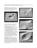
We describe an interactive terrain visualization system which rapidly generates and interactively displays photorealistic three-dimensional (3-D) models produced from stereo images. This product,…

ISPRS 2001 Comparison of Shape Models for 433 Eros using Imaging and Altimetry thumbnail

ISPRS 2001 Comparison of Shape Models for 433 Eros using Imaging and Altimetry

application/pdf 52 kB

The NEAR mission produced shape models of asteroid 433 Eros by both the imaging team and the altimetry team. Preliminary models by both teams at the 2 degree x 2 degree resolution, equivalent to…

ISPRS 2001 The Accuracy, Stability and

ISPRS 2001 The Accuracy, Stability and "Value" of Geodetic Reference Parameters for Mars

application/pdf 51 kB

Recent geodetic observations of Mars by the Mars Global Surveyor spacecraft, particularly the altimetry and gravity experiments, have provided a new framework in which Mars may be geodetically…

ISPRS 2001 Topographic Mapping of the Galilean and Other Icy Satellites: Prospects and Problems for Stereo and Photoclinometry thumbnail

ISPRS 2001 Topographic Mapping of the Galilean and Other Icy Satellites: Prospects and Problems for Stereo and Photoclinometry

application/pdf 107 kB

The utility (read: need) of topographic data in formulating and testing hypotheses for the formation of geologic features is undisputed. In the absence of laser altimeters, however, image-based…

ISPRS 2001 Utilizing Mars Digital Image Model (MDIM) and Mars Orbiter laser Altimeter (MOLA) data for photogrammetric control thumbnail

ISPRS 2001 Utilizing Mars Digital Image Model (MDIM) and Mars Orbiter laser Altimeter (MOLA) data for photogrammetric control

application/pdf 32 kB

The USGS is producing digital elevation models (DEM) and topographic maps of Mars at scales of 1:250,000 to 1:1,000,000. The initial source material will be Viking Orbiter images, with a later…

ISPRS 2001 Combining Lunar Photogrammetric Topographic Data with Clementine LIDAR Data thumbnail

ISPRS 2001 Combining Lunar Photogrammetric Topographic Data with Clementine LIDAR Data

application/pdf 35 kB

During the Clementine Mission both oblique and vertical multispectral images were collected. The oblique and vertical images from a single spectral band collected during the same orbit form a stereo…

ISPRS 2001 An Orthoimage Map using data obtained from the Mars Orbiter Camera of Mars Global Surveyor thumbnail

ISPRS 2001 An Orthoimage Map using data obtained from the Mars Orbiter Camera of Mars Global Surveyor

application/pdf 42 kB

A basic requirement for the planning of future, perhaps even manned Mars missions are precise and high resolution maps of our neighbour planet and, especially, of the landing area. Here we present a…