Lunar M3 Water Map PDS4 Archive
- Originators
- Shuai Li , A. R. Poppe, T. M. Orlando, B. M. Jones, O. J. Tucker, W. M. Farrell, A. R. Hendrix
- Publisher
- USGS Astrogeology Science Center
- Publication Date
- 2022-12-22
- Abstract
-
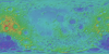
These water maps and their ancillary data were prepared for studying the effects of Earth's magnetotail on the formation of the lunar surface water by Dr. Shuai Li at University of Hawaii. It is very challenging to discriminate OH from H2O based on their overlapped absorptions near 3 µm in the Chandrayaan-1 Moon Mineralogy Mapper (M3) data and they are thus grouped as "water". M3 data from 5 optical periods (OPs) were used and the pixel with the minimum phase angle was used during mosaic. All M3 data were projected using a simple cylindrical projection algorithm. The lunar phase and local time for each M3 pixel can be found in the associated ancillary files. Please use this dataset with caution for other purposes.
All M3 images in five OPs were thermally corrected using the empirical algorithm developed by Li and Milliken [2016]. The lunar phase of each M3 image cube was calculated using JPL-provided SPICE kernels in conjunction with the M3 data acquisition time. The absolute water content of the global lunar surface was mapped from the absorption strength near 3 µm of M3 data using the algorithm in [Li and Milliken, 2017]. The absorption strengths near 3 µm of M3 data were characterized using the Hapke Effective Single Particle Absorption Thickness (ESPAT) parameter [Hapke, 1981; Li and Milliken, 2017]. The absolute water content was then derived from the ESPAT values using an empirical equation: water (ppm) = 5000 * ESPAT [Li and Milliken, 2017]. The mapping uncertainty was estimated to be 20% of mapped water from laboratory experiments [Li and Milliken, 2017].
PDS4 DOI: 10.17189/gmce-w279 Citation: Shuai Li, A. R. Poppe, T. M. Orlando, B. M. Jones, O. J. Tucker, W. M. Farrell, and A. R. Hendrix (2023), New formation processes of lunar surface water in Earth's magnetotail, Nature Astronomy. References: Hapke, B. (1981), Bidirectional reflectance spectroscopy: 1. Theory, Journal of Geophysical Research: Solid Earth, 86(B4), 3039-3054. Li, S. (2016), Water on the Lunar Surface as Seen by the Moon Mineralogy Mapper: Distribution, Abundance, and Origins, Brown University. Li, S., and R. E. Milliken (2016), An empirical thermal correction model for Moon Mineralogy Mapper data constrained by laboratory spectra and Diviner temperatures, J Geophys Res-Planet, 121(10), 2081-2107. Li, S., and R. E. Milliken (2017), Water on the surface of the Moon as seen by the Moon Mineralogy Mapper: Distribution, abundance, and origins, Science advances, 3(9), e1701471. Lundeen, S., M. Stephanie, and A. Rafael (2011), Moon Mineralogy Mapper Data Product Software Specification.
Contact and Distribution
- Format
- Archive, Global Mosaic, Raster Data, Remote-sensing Data
- Access Constraints
- None
- Access Scope
- PDS
- Use Constraints
- Please cite authors
- Native Data Set Environment
- Astrogeology Theme
- Geographic Information System (GIS), Hydrology, Remote Sensing, Selenology, Water
- Mission Names
- Chandrayaan
- Online Package Link
- https://astrogeology.usgs.gov/search/map/lunar_m3_water_map_pds4_archive
- External File Size
- (18 mosaics, 34 GB total)
- Online File Link
- https://pdsimage2.wr.usgs.gov/Individual_Investigations/moon_m3_lunarwater_li_2023/
- Contact Address
- 2255 N. Gemini Drive
- Contact City
- Flagstaff
- Contact State
- AZ
- Contact Postal Code
- 86001
- Contact Email
- [email protected]
- Currentness Reference
- Publication date
- Progress
- Complete
- Update Frequency
- None planned
- Process Description
- see: Shuai Li, A. R. Poppe, T. M. Orlando, B. M. Jones, O. J. Tucker, W. M. Farrell, and A. R. Hendrix (2023), New formation processes of lunar surface water in Earth's magnetotail", Nature Astronomy.
Lineage
- Process Date
- 2022-12-22
- Source Title
- Moon Mineral Mapper (M3)
- Source Online Linkage
- https://pds-imaging.jpl.nasa.gov/volumes/m3.html
- Source PDS Archive
- Chandrayaan 1
- PDS Status
- PDS 4 Archived
Geospatial Information
- Target
- Moon
- System
- Earth
- Minimum Latitude
- -90
- Maximum Latitude
- 90
- Minimum Longitude
- -90
- Maximum Longitude
- 90
- Direct Spatial Reference Method
- Raster
- Object Type
- Grid Cell
- Bit Type (8, 16, 32)
- 32
- Quad Name
- Radius A
- 1737400
- Radius C
- 1737400
- Bands
- 1
- Pixel Resolution (meters/pixel)
- 280
- Scale (pixels/degree)
- 108.3
- Map Projection Name
- Simple Cylindrical
- Latitude Type
- Planetocentric
- Longitude Direction
- Positive East
- Longitude Domain
- -180 to 180