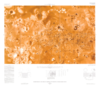
CARTOGRAPHIC CONTROL Mercator and polar stereographic projections used for the maps of Io are based on a sphere with a radius of 1816 km and a common scale of 1: 4,268,000 at lats ±45˚. Longitudes…
The images used for the base of this globe were chosen from coverage supplied by the Galileo solid-state imaging (SSI) camera and Voyager 1 and 2 spacecraft. The monochrome and color data were both…
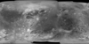
This global map base of Ganymede utilizes the best image quality and moderate resolution coverage supplied by Galileo SSI (Solid State Imaging instrument) and Voyager 1 and 2. The image processing…
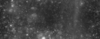
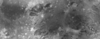
A global monochrome mosaic of the best resolution images from both Galileo and Voyager 1 was created that includes 51 Voyager 1 images with spatial resolutions sometimes exceeding the 1 km/pixel…
This basemap of Jupiter’s moon Io was produced by combining the best images from both the Voyager 1 and Galileo Missions. Although the subjovian hemisphere of Io was poorly seen by Galileo,…
This global map of Callisto utilizes the best image quality and moderate resolution coverage supplied by Galileo SSI (Solid State Imaging instrument) and Voyager 1 and 2. The image processing was…
The images used for the base of this globe were chosen from the best image quality and moderate resolution coverage supplied by Galileo SSI and Voyager 1 and 2 (Batson, 1987; Becker and others, 1998;…