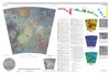
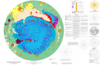
The Themis Regio quadrangle (V-53), Venus, has been geologically mapped at 1:5,000,000 scale as part of the NASA Planetary Geologic Mapping Program. The quadrangle extends from lat 25° to 50° S.…
Artemis, named for the Greek goddess of the hunt, represents an approximately 2,600 km diameter circular feature on Venus, and it may represent the largest circular structure in our solar system.…
Product Information: This global false color mosaic was constructed from low phase angle violet, green, and near-infrared (756 nanometer) images from orbits G2, E6, C9, and C21 of the Galileo…
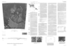
Io, the innermost Galilean satellite of Jupiter, is about the same size as Earth’s Moon, but its surface properties and geologic processes are significantly different. Impact craters and basins,…
The north polar region of Mars occurs within the central and lowest part of the vast northern plains of Mars and is dominated by the roughly circular north polar plateau, Planum Boreum. The northern…
Deuteronilus Mensae, first defined as an albedo feature at lat 35.0 deg N., long 5.0 deg E., by U.S. Geological Survey (USGS) and International Astronomical Union (IAU) nomenclature, is a gradational…
Mars Transverse Mercator (MTM) -20012 and -25012 quadrangles (lat 17.5 deg - 27.5 deg S., long 345 deg - 350 deg E.) cover a portion of Margaritifer Terra near the east end of Valles Marineris. The…
Introduction Rock units were deposited on Mars by meteorite impact, volcanism, wind, flowing water, standing water, and ice, acting separately or in concert. Hellas Planitia, the deepest tract on…
Introduction Mars Transverse Mercator (MTM) -30262 and -30267 quadrangles cover the summit region and east margin of Hadriaca Patera, one of the Martian volcanoes designated highland paterae. MTM…
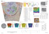
The Magellan spacecraft orbited Venus from August 10, 1990, until it plunged into the Venusian atmosphere on October 12, 1994. Magellan Mission objectives included (1) improving the knowledge of the…