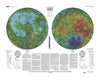
This sheet is one in a series of topographic maps that presents colorcoded topographic data digitally merged with shaded relief data. The figure for the Moon, used for the computation of the map…
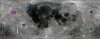
Product Information: This mosaic represents a reduced-resolution version of the standard calibration Clementine near-infrared (NIR) mosaic processed to 500 meters per pixel (m) as an ISIS cube (70°…
We present a toolkit of routines for IDL. This toolkit converts a set of coordinates and data sorted by acquisition time into a map. It was developed at first for low-resolution data that require…
The first decade of the 21st century has seen a new golden age of lunar exploration, with more missions than in any decade since the 1960’s and many more nations participating than at any time in…