This mosaic represents the Thermal Emission Imaging System (THEMIS) -daytime infrared (IR) 100 meter/pixel mosaic (version 12) released in the summer of 2014 by Arizona State University. Values…
Product Information: This global map of Saturn's moon Tethys was created using images taken during Cassini spacecraft flybys which mostly occurred during the Solstice mission extension. The map is…
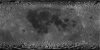
Product Information: Lunar Reconnaissance Orbiter Camera (LROC) Wide Angle Camera (WAC) aboard the Lunar Reconnaissance Orbiter (LRO) has allowed the instrument team to create a global mosaic…
This product is a cartographically controlled mosaic of Mars Charts (MC) 08 through 23, covering 50.0 percent of Mars' surface, from -30 deg N to +30 deg N latitude and 0–360 deg E longitude. The…
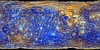
This mosaic shows Mercury's colors as viewed by placing images from MESSENGER's 1000 nm, 750 nm, and 430 nm narrow-band filters in the red, green, and blue channel respectively. This is not what…
This mosaic shows Mercury's surface in "enhanced color," a term used to describe a color scheme created to emphasize color differences on Mercury's surface. This is not what Mercury would look like…
This mosaic represents the Thermal Emission Imaging System (THEMIS) -nighttime infrared (IR) 100 meter/pixel mosaic (version 12) released in the summer of 2014 by Arizona State University. Values…
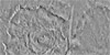
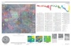
This publication provides a geological map of Lada Terra quadrangle (V56), a portion of the southern hemisphere of Venus that extends from lat 50° S. to 70° S. and from long 0° E. to 60° E. V56…
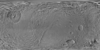
The Snegurochka Planitia region is a predominantly low-lying terrain that covers the north polar region of Venus, extending from lat 75° N. to 90° N. and from long 0° E. to 360° E. The plains…
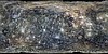
The Hecate Chasma quadrangle (V-28) extends from lat 0° to 25° N. and from long 240° E. to 270° E. The quadrangle was mapped at 1:5,000,000 scale as part of the National Aeronautics and Space…