This map is one in a series of 1:500,000-scale geologic maps initiated by the National Aeronautics and Space Administration to investigate areas of particular scientific interest on…
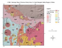
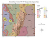
The east Mangala Valles area merits detailed geologic study because it contains several small channels whose ages can be determined relative to geologic units that range in age from early (Noachian)…
We present a GIS package for the 1:2,500,000 geological map of the Alpha Regio (V-32) quadrangle, Venus. The V-32 quadrangle extends from 0° to 25 S, 0°to 30° E with an area of approximately…
The original Geologic Map of Mars by David H. Scott and Michael H. Carr (1978) was created from images acquired during the Mariner 9 television experiment. The equatorial region, which lies between…
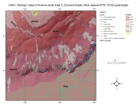
The map area is in the Mangala-Memnonia region which contains remarkably diverse geologic features and terrain types. Studies of the Mariner 9 images revealed the wide range of ages of the major rock…
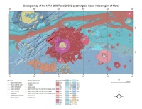
The original map document was created in 1992 as a Mercator projection and is based on older Viking images. It was scanned and georeferenced into ArcGIS in two parts that are located in…
Recent geodetic observations of Mars by the Mars Global Surveyor spacecraft, particularly the altimetry and gravity experiments, have provided a new framework in which Mars may be geodetically…
On such a volcanically active world as Io, topography is especially important for understanding lava emplacement, mountain formation, internal dynamics, and volcanic history. Previously we have…
The Mars Crater Morphology Consortium was formed in 1997 to facilitate exchange of martian impact crater data among researchers through standardizing nomenclature, integrating crater databases into…