The High Resolution Stereo Camera (HRSC) on board of the European space mission Mars Express provides multispectral digital image data in high resolution as well as the systematic stereo coverage of…
Positional control for MDIM 2.1 comes from a new geodetic/photogrammetric solution of the global Mars Mariner 9 and Viking image control network. The details of this network solution are described…
The images obtained by the HRSC (High Resolution Stereo Camera) on Mars Express show excellent potential for topographic mapping of the planet. The derived stereo models agree with topographic data…
We describe a series of programs and scripts under development for the USGS digital cartography and image processing software system ISIS that will make it possible for users to create digital…
Topographic mapping of icy satellites is a critical tool for evaluation of geologic problems ranging from the origin of ionian mountains to the thickness of floating ice shells. With the lack of…
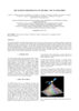
On such a volcanically active world as Io, topography is especially important for understanding lava emplacement, mountain formation, internal dynamics, and volcanic history. Previously we have…
Digitization and cartographic processing of 5 Lunar Orbiter (LO) IV frames (109H, 110H, 114H, 115H, and 114M) are now complete, and these data are available online at…
More than ever before the planet Mars is subject to exploration and mapping activities. Since 1992 the Technical University of Berlin was involved in the software development for photogrammetric and…
Following the successful landing of the Mars Pathfinder, DLR has carried out a comprehensive study of the Pathfinder landing site in terms of geology, mineralogy, and surface photometric properties.…
We describe USGS topomapping of Mars at resolutions from 100 m to 30 µm with data from the latest spacecraft missions. Analysis of NASA 2001 Mars Odyssey Thermal Emission Imaging System (THEMIS)…