Products

1000 Results Collapse
ISPRS 2003 Formulas of the Perspective Cartographic Projection for Planets and Asteroids of Arbitrary Shape thumbnail

ISPRS 2003 Formulas of the Perspective Cartographic Projection for Planets and Asteroids of Arbitrary Shape

application/pdf 42 kB

Formulas of transformation between coordinates on image plane, planetocentric coordinates and photometric conditions of observation for arbitrary planet have been obtained. An example with…

ISPRS 2003 Approaches for a Combined Adjustment of HRSC Image Data and MOLA Control Information thumbnail

ISPRS 2003 Approaches for a Combined Adjustment of HRSC Image Data and MOLA Control Information

application/pdf 200 kB

In this paper we focus on a detail concerning the estimation of exterior orientation parameters of the High Resolution Stereo Camera (HRSC) orbiting planet Mars during the European Mars Express…

ISPRS 2003 Topography of Io: Methods to Mapping Local and Regional Geology thumbnail

ISPRS 2003 Topography of Io: Methods to Mapping Local and Regional Geology

application/pdf 125 kB

On such a volcanically active world as Io, topography is especially important for understanding lava emplacement, mountain formation, internal dynamics, and volcanic history. Previously we have…

ISPRS 2003 Registration and its Uncertainty of MOLA Profiles with MOC Stereo Images thumbnail

ISPRS 2003 Registration and its Uncertainty of MOLA Profiles with MOC Stereo Images

application/pdf 56 kB

The high resolution instruments on board the Mars Global Surveyor (MGS) provide the necessary data to survey the Martian topographic surface in the finest detail so far [Albee, et al, 2002]. However,…

ISPRS 2002 Mars Geodesy / Cartography Working Group Recommendations on Mars Cartographic Constants and Coordinate Systems thumbnail

ISPRS 2002 Mars Geodesy / Cartography Working Group Recommendations on Mars Cartographic Constants and Coordinate Systems

application/pdf 156 kB

NASA's Mars Geodesy/Cartography Working Group (MGCWG), established in 1998 and chaired since 2000 by one of us (TCD), consists of leading researchers in planetary geodesy and cartography at such…

ISPRS 2002 High-Resolution Topomapping of Mars Orbiter Camera Narrow-Angle Images thumbnail

ISPRS 2002 High-Resolution Topomapping of Mars Orbiter Camera Narrow-Angle Images

application/pdf 800 kB

We describe our initial experiences producing controlled digital elevation models (DEMs) of Mars with horizontal resolutions of ≤10 m and vertical precisions of ≤2 m. Such models are of intense…

ISPRS 2002 Photogrammetric Registration of MOC Imagery to MOLA Profile thumbnail

ISPRS 2002 Photogrammetric Registration of MOC Imagery to MOLA Profile

application/pdf 292 kB

The current Mars Global Survey (MGS) mission has been collecting high resolution digital images (MOC) and laser ranges (MOLA). The processing MOLA range data results in a global digital elevation…

ISPRS 2002 An Orthoimage Map using data obtained from the Mars Orbiter Camera of Mars Global Surveyor thumbnail

ISPRS 2002 An Orthoimage Map using data obtained from the Mars Orbiter Camera of Mars Global Surveyor

application/pdf 1,019 kB

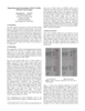
A basic requirement for the planning of future Mars missions are precise and high resolution maps, especially, of the landing site area. We present a new digital orthoimage map of Mars using data…

ISPRS 2001 Planetary Cartography as MSSS thumbnail

ISPRS 2001 Planetary Cartography as MSSS

application/pdf 3 MB

Though the primary focus at Malin Space Science Systems (MSSS) is on building and operating instruments through the archiving of raw data, we have also pursued research interests in planetary…

ISPRS 2001 Mars Godesy / Cartography Working Group Recommendations on Mars Cartographic Constants and Coordinate Systems thumbnail

ISPRS 2001 Mars Godesy / Cartography Working Group Recommendations on Mars Cartographic Constants and Coordinate Systems

application/pdf 57 kB

NASA's Mars Geodesy/Cartography Working Group (MGCWG), established in 1998 and chaired since 2000 by one of us (TCD), consists of leading researchers in planetary geodesy and cartography at such…

Project Pages

30 Results Collapse

Documents

104 Results Collapse