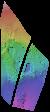
Product Information: This uncontrolled Digital Elevation Model (DEM) was created to investigate the terrain of the Tvashtar Paterae volcanic region on Io, using stereo imagery from the Galileo…
Observation Guide labeling the individual images used to make up the 2010 Mercury Messenger Global Mosaic.
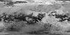
Product Information: This mosaic represents the best geodetic map of Mercury's surface as of 2010. In 2008 the MESSENGER spacecraft made two close flybys (M1 and M2) of Mercury and imaged about 74%…
This 2.5D shape model of Enceladus was generated by interpolating the associated 3D point cloud of latitude, longitude, radius values, minus the mean radius of Enceldaus (251500 meters), to a regular…
This 2.5D topographic model of Enceladus was created by first generating a fully 3D shape (radius) model from a dense network of image tie points and photogrammetrically solving for point latitude,…
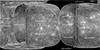
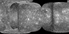
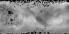
Product Information: This mosaic represents the completion of a global control network of Enceladus containing Cassini Imaging Science Subsystem (ISS) images. A total of 586 images in CLR, GRN, UV3,…
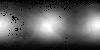
Product Information: The Dawn framing camera (FC) acquired images of Ceres with a resolution of about 400 meters per pixel (m) during approach in 2015 (Preusker et al., 2016). German Aerospace…
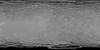
Product Information: This global digital map of Saturn's moon Titan was created using images taken by the Cassini spacecraft's Imaging Science Subsystem (ISS). The map was produced in June 2015…
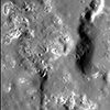
Product Information: The discovery of hollows on Mercury remains one of the most surprising scientific findings by MESSENGER. Hollows are sharp-edged, irregular, rimless pits that are often…