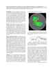
This product is an infrared image mosaic generated using Thermal Emission Imaging System (THEMIS) images from the 2001 Mars Odyssey orbiter mission. The mosaic is generated at the full resolution of…
This product is a daytime infrared image mosaic generated using Thermal Emission Imaging System (THEMIS) images from the 2001 Mars Odyssey orbiter mission. The mosaic is generated at the full…
Positional control for MDIM 2.1 comes from a new geodetic/photogrammetric solution of the global Mars Mariner 9 and Viking image control network. The details of this network solution are described…
The stereo photogrammetric observable equations are presented relating control point image location to camera distortions, camera pointing, spacecraft position, Mars-fixed areocentric control point…
The current global spatial control net of Mars provides the geodetic basis for an orthoimage map composed of image data sets obtained from VIKING missions from 1976 to 1980. This map is not…
The USGS is producing digital elevation models (DEM) and topographic maps of Mars at scales of 1:250,000 to 1:1,000,000. The initial source material will be Viking Orbiter images, with a later…
The MGS Orbiter is carrying the high-precision Mars Orbiter Laser Altimeter (MOLA) which, when combined with precision reconstructed orbital data and telemetered attitude data, provides a tie between…
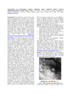
To assist in landing site selection, we are compiling a suite of stereo images of potential landing sites for the 1998 and 2001 Mars landers. From these, we are using automated stereogrammetry…
Described the exciting results which have been obtained from the initial set of mainly Northern hemispheric laser altimetry tracks from the MOLA instrument known as the SPO-1 phase. More recently has…