Products

180 Results Collapse
Information for Instrument Teams thumbnail
ISPRS 2004 Digital Cartography with HRSC on Mars Express thumbnail

ISPRS 2004 Digital Cartography with HRSC on Mars Express

application/pdf 8 MB

The High Resolution Stereo Camera (HRSC) on board of the European space mission Mars Express provides multispectral digital image data in high resolution as well as the systematic stereo coverage of…

ISPRS 2004 Quantitative Assessment of Automated Crater Detection on Mars thumbnail

ISPRS 2004 Quantitative Assessment of Automated Crater Detection on Mars

application/pdf 456 kB

Crater Size-Frequency Distributions (SFD) on planetary surfaces are crucial to dating the geological age. On the Moon they have been employed together with radioactive K-Ar techniques to determine…

ISPRS 2004 Some Aspects of Multilingual Planetary Map Producing for Non-Professional Audience: Visualization and Nomenclature thumbnail

ISPRS 2004 Some Aspects of Multilingual Planetary Map Producing for Non-Professional Audience: Visualization and Nomenclature

application/pdf 565 kB

In general, maps should answer a very simple question of its reader: "what's there" and „where is something”? For planetary maps, the answer is more difficult, because (1) in some cases even map…

ISPRS 2004 True-3D Visualization of the Martian Surface Based on Lenticular Foil Technology using HRSC Imagery thumbnail

ISPRS 2004 True-3D Visualization of the Martian Surface Based on Lenticular Foil Technology using HRSC Imagery

application/pdf 389 kB

Following the conceptual idea "from 3D camera to 3D view", the production of true-3D image maps for the glasses-free stereoviewing of parts of the Martian surface, is described. The image data have…

ISPRS 2004 Geomorphometric Mapping of Grand Canyon from the 1-Degree USGS DEMs thumbnail

ISPRS 2004 Geomorphometric Mapping of Grand Canyon from the 1-Degree USGS DEMs

application/pdf 946 kB

In a previous research effort a terrain partition framework was defined allowing the partition of the landscape of Valles Marineris chasma (an elongated steep-sided depression located in Mars) to…

ISPRS 2004 Automation in Mars Landing-Site Mapping and Rover Localization thumbnail

ISPRS 2004 Automation in Mars Landing-Site Mapping and Rover Localization

application/pdf 603 kB

Our project aims to automate Mars mapping and localization using robotic stereo and descent imagery. Stereo vision is a wellstudied domain. However, most efforts aim only at a general scene; little…

ISPRS 2004 Landing Site Mapping and Rover Localization for the 2003 Mars Exploration rover Mission: Technology and Experimental Results thumbnail

ISPRS 2004 Landing Site Mapping and Rover Localization for the 2003 Mars Exploration rover Mission: Technology and Experimental Results

application/pdf 73 kB

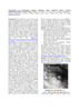
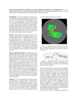
This paper presents the technology and experimental results for high-precision landing-site mapping and rover localization developed for the ongoing 2003 Mars Exploration Rover (MER) mission. This…

ISPRS 2004 Performance of Automatic Tie Point Extraction using HRSC Imagery of the Mars Express Mission thumbnail

ISPRS 2004 Performance of Automatic Tie Point Extraction using HRSC Imagery of the Mars Express Mission

application/pdf 340 kB

In January 2004 the first European interplanetary spacecraft, Mars Express, was inserted successfully into a Martian orbit. The multiline scanner HRSC (High Resolution Stereo Camera) on board of…

ISPRS 2004 Improving the Exterior Orientation of Mars Express HRSC Imagery thumbnail

ISPRS 2004 Improving the Exterior Orientation of Mars Express HRSC Imagery

application/pdf 132 kB

This paper focusses on the estimation of exterior orientation parameters of the High Resolution Stereo Camera (HRSC) orbiting planet Mars during the European Mars Express mission since January 2004.…

Project Pages

2 Results Collapse

Documents

180 Results Collapse
ISPRS 1998 Status of the RAND Control Network of Mars thumbnail

ISPRS 1998 Status of the RAND Control Network of Mars

application/pdf 90 kB

The RAND control network of Mars was begun during the Mariner 9 mission, and it has been expanded and improved since then. The network is based on measurements of points made on images taken by the…

ISPRS 1998 Digital Topographic Mapping of Mercury thumbnail

ISPRS 1998 Digital Topographic Mapping of Mercury

application/pdf 64 kB

We describe a cartographic project to re-process and semi-automatically stereo match Mariner 10 vidicon stereo pair images. Three different patch-based digital stereo matching algorithms have been…

ISPRS 1998 New Map Products from Planet Mars thumbnail

ISPRS 1998 New Map Products from Planet Mars

application/pdf 63 kB

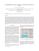
The map sheet "MARS 1:2,000,000 Mouth of Ares and Tiu Valles" presents the mapped area on the planet's northern hemisphere in two different cartographic categories. The Image Map, portraying the…

ISPRS 1998 Getting to know SPICE thumbnail

ISPRS 1998 Getting to know SPICE

application/pdf 62 kB

The SPICE ancillary information system developed at NASA's Jet Propulsion Laboratory offers a flexible, multimission suite of data containers and related software--a subroutine library--for…

ISPRS 1999 Assessment of Published Viking Orbiter DEMs derived from Stereo Photogrammetry using MOLA Data thumbnail

ISPRS 1999 Assessment of Published Viking Orbiter DEMs derived from Stereo Photogrammetry using MOLA Data

application/pdf 2 MB

Described the exciting results which have been obtained from the initial set of mainly Northern hemispheric laser altimetry tracks from the MOLA instrument known as the SPO-1 phase. More recently has…

ISPRS 1999 Triaxial Ellipsoid as a Reference-Surface on Mars Mapping thumbnail

ISPRS 1999 Triaxial Ellipsoid as a Reference-Surface on Mars Mapping

application/pdf 59 kB

At the development of a mathematical basis of cartographic products the problems of selection of a reference-surface system, system of coordinates, and also selection and elaboration of cartographic…

ISPRS 1999 Revision of the Mars Control Net and Global Digital Image Mosaic thumbnail

ISPRS 1999 Revision of the Mars Control Net and Global Digital Image Mosaic

application/pdf 31 kB

In the late 1980s, the USGS, Flagstaff, produced the first in what would become a series of very large, global digital image mosaics of solar system bodies. This Mars mosaicked digital image model…

ISPRS 1999 A Database of Viking Orbiter Image Coverage of Mars for Cartographic and Scientific Use thumbnail

ISPRS 1999 A Database of Viking Orbiter Image Coverage of Mars for Cartographic and Scientific Use

application/pdf 2 MB

Viking Orbiters 1 and 2 collectively returned more than 46,000 images of Mars between 1976 and 1980. Numerous observation sequences with different objectives resulted in an extremely complex and…

ISPRS 1999 USGS Mapping of the Mars Pathfinder Landing Site: Progress and Plans thumbnail

ISPRS 1999 USGS Mapping of the Mars Pathfinder Landing Site: Progress and Plans

application/pdf 112 kB

This abstract describes progress in cartographic processing of data from the Imager for Mars Pathfinder (IMP) by the U. S. Geological Survey in the past year, and plans for advanced cartographic…

ISPRS 1999 Stereogrammetric Mapping on Mars: Promise, Progress, and Problems thumbnail

ISPRS 1999 Stereogrammetric Mapping on Mars: Promise, Progress, and Problems

application/pdf 46 kB

To assist in landing site selection, we are compiling a suite of stereo images of potential landing sites for the 1998 and 2001 Mars landers. From these, we are using automated stereogrammetry…